A Newly Discovered Map by Antoine-Simon Le Page du Pratz
From Mississippi Bubble to “Fleuve St. Louis,” a new portrait of America’s greatest river
Many readers of Common-place know how serendipity can aid in archival research. Some scholars spend days or weeks as well as thousands of dollars to work in an archive, only to find little that advances their project. Others, more fortunate, travel to an archive to read one thing but then chance upon an unexpected document that sends their research in new directions. I am grateful to count myself among a few who have encountered a completely unexpected new document, without even going to look for it, because it found me.
For many years I have had an abiding interest in the eighteenth-century French Louisiana colonist Antoine-Simon Le Page du Pratz, who lived in Louisiana from 1718 to 1734 and wrote a three-volume, 1300-page Histoire de la Louisiane, published in Paris in 1758. In part because his book has never been translated in its entirety into English, Le Page has received limited attention from specialists in colonial American literature and history. To redress this, I have translated about a quarter of the text into English, including his ethnography of the Natchez Indians and narrative of their massacre of 240 French colonists at Natchez in 1729. My efforts have been sporadic, performed in spare hours with occasional help from French-speaking research assistants. I cannot boast of strong html-programming skills, and my Web page, now combined with my further work on Le Page’s rival François-Benjamin Dumont de Montigny, has the appearance of an amateur production. But because Le Page du Pratz is obscure and has an unusual name, my site has long appeared among the top three results of Google searches, and I periodically receive thanks and queries from people who have consulted it, most often residents of Louisiana or Mississippi who are interested in genealogy, local history, and even topics such as the oyster and fish populations of the lower Mississippi three centuries ago.
The most fortuitous surfer to find my site wrote to me in May 2007. New York City map dealer Martayan Lan had acquired, from an anonymous seller in France, a manuscript map of Louisiana that appeared to be the work of Le Page du Pratz (fig. 1). It depicts a portion of the Gulf Coast and most of the Mississippi basin as far north as the Illinois country and is titled across the top Carte de la Province et Colonie de la Loüisiane, Dans la partie septentrional de l’Amerique; La quelle est arosée du fameux fleuve St. Loüis, avec une explication des environs de ce fleuve, jusques aux endroits les plus eloignez ou sont habitez les français; ensemble la position présente des différentes Nations des Naturels Ameriquains, et ce que chaque partie du païs raporte naturellement (Map of the Province and Colony of Louisiana, in the northern part of America, which is watered by the famous St. Louis River; with an explication of the surroundings of this river, to the most distant regions inhabited by the French, together with the present location of the different Nations of the American Indians, and the natural productions of each part of the country). Robert Augustyn of Martayan Lan wrote to ask me if I could provide a date and some historical background for the map, and because I could not travel to New York on short notice to see it, he sent me a series of detailed scans of the manuscript.

In the lower-left corner, the map is signed by “Le Sr. Le Page du Prat, ingénieur Machiniste du Roy; architecte pour le civil et pour l’hydraulique.” I was interested to see that this self-description matches closely the one Le Page gave himself when he published a short essay in November 1751 in the Journal Œconomique, a Paris periodical devoted to scientific and commercial topics. The essay was titled “Concernant le Desséchement des Maraïs, & le moyen de faire des levées solides, par M. Le Page du Pratz Ingénieur Machiniste & Hydraulique” (Concerning the draining of swamps, and the method of making solid levees, by Monsieur Le Page du Pratz, Mechanical and Hydraulic Engineer). The article did not mention Louisiana, but it included a diagram of a dredging machine and described issues of soil quality and permeability that must have reflected his experience draining farmland and building levees in Louisiana. In lines that eerily remind one of the levee failures following Hurricane Katrina, Le Page wrote of “le peu de solidité des levées” (the lack of solidity in the levees) (72).
I had found Le Page’s article on marshland drainage many years earlier while reading at the New York Public Library his “Mémoire sur la Louisiane,” a series of twelve installments published between September 1751 and February 1753 in the Journal Œconomique (now available at only a few U.S. libraries). This series contained in abbreviated form the material Le Page later published in his 1758 book, and in between the second and third installments he published the treatise on swamp drainage. A single reference in that article to the locality of his work was also the first clue to Le Page’s whereabouts between 1734 and 1751: “l’experience que j’ai acquies par le séjour que j’ai fait (à Fontenoi-le-Comte en bas Poitou) sur le bord des Marais” (the experiments that I conducted during the time I spent at the edge of the swamps in Fontenay-Le-Comte in Poitou) (74). The Marais Poitevin, a region of coastal wetlands north of La Rochelle, was at that time a remote region inhabited by independent-minded peasants who lived and moved largely by boat. Draining and developing the area was an act of imperial politics as well as an engineering project.
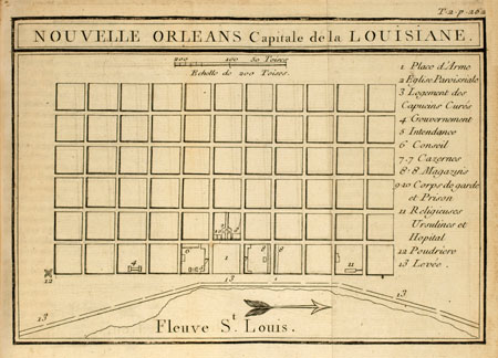
The same could be said of New Orleans, founded at the time Le Page arrived in the colony and depicted in the inset in the corner of the manuscript map. The regular square street grid that became today’s French Quarter resembles the plat of countless U.S. small towns, but to eighteenth-century French eyes such a design was a radical innovation. The inset map matches very closely the engraved map of the city published in Le Page’s 1758 book (fig. 2). Both depict only a few public buildings, among them the Ursuline convent and hospital located at the east or downstream end of the city and constructed in 1732-1734. The convent was one solid clue to the map’s date. Given this and because Le Page wrote that he returned to France in 1734, it seemed likely that he would have drawn the map shortly after his return. Like many contemporary cartographers of Louisiana, Le Page enhanced his map with narrative history by adding an “Explication des Chiffres,” descriptions of notable features and events keyed to numbers (“Chiffres”) on the map. Chiffre 14 refers to the Natchez revolt of 1729 and to the Natchez nation as “tres belle et tres affable” (very attractive and very friendly), consistent with Le Page’s strong sympathy for the tribe and friendship with its leader Serpent Piqué, as expressed in his book. Another temporal parameter is the fact that although the map shows a “fort des chicachas” (Chickasaws) near the “Rivière de la Mobile” (today the Tombigbee River), there is no reference in the “Explication des Chifres [sic]” to the French attack on the Chickasaw town of Ackia in May 1736. If he had known of the battle when he drew the map he would certainly have referred to it. In his 1758 book, Le Page perceived the need to bring his history of the colony up to date, beyond the year he returned to France, by including a narrative of the 1735-36 Chickasaw War, and so he copied it from the work of Dumont de Montigny, who had published Mémoires historiques sur la Louisiane in 1753.
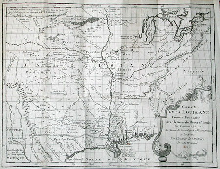
At first glance the map may not seem like the work of one of the best-informed Frenchmen in colonial Louisiana, and it bears little resemblance to the fold-out frontispiece map in Le Page’s 1758 book (fig. 3). Instead it appears as a simple branching tree of the Mississippi and its tributaries. On these waterways Frenchmen traveled in canoes, pirogues, and flatboats, for they rarely voyaged overland. My study in Paris archives of the manuscript maps by Dumont de Montigny and by other engineers, missionaries, and soldiers had taught me that the skills of a surveyor rarely coincided with those of a gifted writer. Yet technical training in engineering, surveying, and mapmaking carried a great deal of prestige in the French military and in colonial society in the early eighteenth century. Le Page was not a military officer, but he was eager to boast of his skills as an engineer, whether dredging canals or drawing maps.

For my own interests the most intriguing thing on the newly discovered map is a conspicuous absence. In 2005, I wrote in Common-place about the voyage of Moncacht-apé, a Yazoo Indian whom Le Page claimed to have met at Natchez in the 1720s. A long episode in his book (volume III, chapters 6-8; translated on my Website) and a somewhat shorter version in his articles in the Journal Œconomique were devoted to a first-person narrative by Moncacht-apé of how he traveled up the Missouri, crossed the height of land to a “Belle Rivière,” and descended this river to the “Mer de Sud” or Pacific Ocean. In the upper-left corner of his 1758 published map, Le Page indicated the “route de Mon-cacht-apé” from the upper Missouri River northward to the “Belle Rivière,” a river which flows westward off the corner of the map. Of course, the dream of a route through the continent to the Pacific continued to entice explorers until the time of Lewis and Clark, who took Thomas Jefferson’s copy of the abridged 1763 English translation of Le Page du Pratz’s book with them on their expedition. Thus it is significant that the new manuscript map does not include the “Belle Rivière” or any indication of a route from the Missouri River to the Pacific. Instead, Le Page simply wrote next to the upper Missouri, “Rivierre du Missouris qu’est toujours trouble. Elle a 800 lieues de cours elle passent dans les prairies immenses” (Missouri River which is always turbid. It is 800 leagues long and flows through immense prairies). The stated distance, 2400 miles at 3 miles per league, is quite accurate, as is the reference to its muddy or cloudy water.
When I wrote about Moncacht-apé for Common-place, amidst a flurry of celebrations of the bicentennial of the Lewis and Clark expedition, I was excited by the possibility that an obscure Indian had accomplished the transcontinental journey decades before Meriwether and William or the erstwhile Alexander McKenzie achieved it. But I tried to temper my excitement with skepticism. The more I have read and learned about Le Page du Pratz, the more I have found that his writings in the 1750s were embellished with fantasies: a romantic primitivism that defended Native Americans (whom he called “naturels” rather than “sauvages”) against the short-sighted blunders of French officials and a clever imagination that exploited the dreams of French colonizers even as they faced the possibility that defeat in the Seven Years War would mean the loss of Louisiana and Illinois. The new manuscript map appears to prove once and for all that the Moncacht-apé story is a fabrication.
Of the many words on the map, references to events in the history of French Louisiana are outnumbered by the many references to minerals and food. Le Page’s goal seems to have been to promote the value of the colony through its fertile prairies, abundant wildlife, and plentiful foodstuffs. This kind of boosterism could be lucrative insofar as the author might be able to sell land claims or raise money from investors to finance an expedition to exploit such resources. I recently discovered that Le Page wrote up a proposal in 1750 to lead such an expedition back to Louisiana. But making such claims also carried risks, particularly in light of the still-powerful memory of the Mississippi Bubble’s bursting in 1720. Le Page sailed to Louisiana during the brief period when large sums of money were invested by concessionaires (including Le Page himself) in a pyramid scheme concocted by the infamous John Law. There were several promotional tracts published, rumors circulated of silver or gold mines along the Arkansas River, and thousands of settlers arrived hoping to develop the region’s riches. Yet nearly all these investors lost money, and the Louisiana Colony obtained a reputation not unlike Enron, as a scam perpetrated by politically well-connected crooks. The manuscript map downplays hopes of silver and gold and promotes instead less valuable minerals and especially food, such as “arbres fruitiers” (fruit trees) and “de fraizes, champignons, Morilles et simples Medicinales” (strawberries, mushrooms, Morels and medicinal herbs). Le Page in his book praised the skills of Native American healers and explained how he had collected herbs to send on to France (his efforts should not be confused, however, with those of Jean and Louis Prat, the leading French doctors in New Orleans at the time). The map expresses a special interest in chestnuts (chataignes or marrons in French), which were much more common before a blight decimated the trees in the early twentieth century. We read, right across the middle of the map, “Dans presque tous les Costeaux du païs il y a des chataignes faites comme des glans, et l’on ne les distingue que par le gout, le bois et la feuille … sans doute que ce sont les glans que l’on dit que nos premiers peres mangeoient” (On nearly all the hills of the country there are Chestnuts made like acorns, and one can distinguish them only by the taste, the wood and the leaf … no doubt these are the acorns that it is said our first fathers ate). These lines are a version of the pastoral utopian vision often deployed in promotional tracts, and his map is a promotional tool from a distant and optimistic past. This map makes a rich contribution to American history, and so I was very pleased when it was subsequently purchased by the Library of Congress and made available to the public and on the Internet. Who knows if another work by Le Page may soon come to light.
Further Reading:
The best discussion of Le Page’s possible influence on Lewis and Clark that I have found is in John Logan Allen, Passage through the Garden: Lewis and Clark and the Image of the American Northwest (Urbana, Ill., 1975).
For more on Le Page’s ironic promotional writing, see my essay, “Le Page du Pratz’s Fabulous Journey of Discovery: Learning about Nature Writing from a Colonial Promotional Narrative,” in Steven Rosendale, ed., The Greening of Literary Scholarship: Literature, Theory, and the Environment (Iowa City, 2002): 26-41. Shannon Dawdy’s Building the Devil’s Empire: French Colonial New Orleans (Chicago, 2008) describes the founding of the city and the origins of its reputation as a refuge for vagrants and libertines.
This article originally appeared in issue 9.4 (July, 2009).
Gordon Sayre is professor of English at the University of Oregon and a specialist in French and English colonial literature of North America. He is coeditor of the manuscript memoir by Dumont de Montigny, Regards sur le monde atlantique, 1715-1747, published by Septentrion (2008).