A renaissance is occurring in the study of American cartography. Just a decade ago, rare early maps of North America were accessible mainly through small black and white reproductions scattered unindexed across many books, journals, and posters. Now many of these maps are easily available, thanks to innovative zoom, scan, and track software deployed on major library Websites such as Gallica from the Bibiliothèque national de France. Many smaller libraries and even private collectors like David Rumsey also offer these digital tools for viewing their maps.
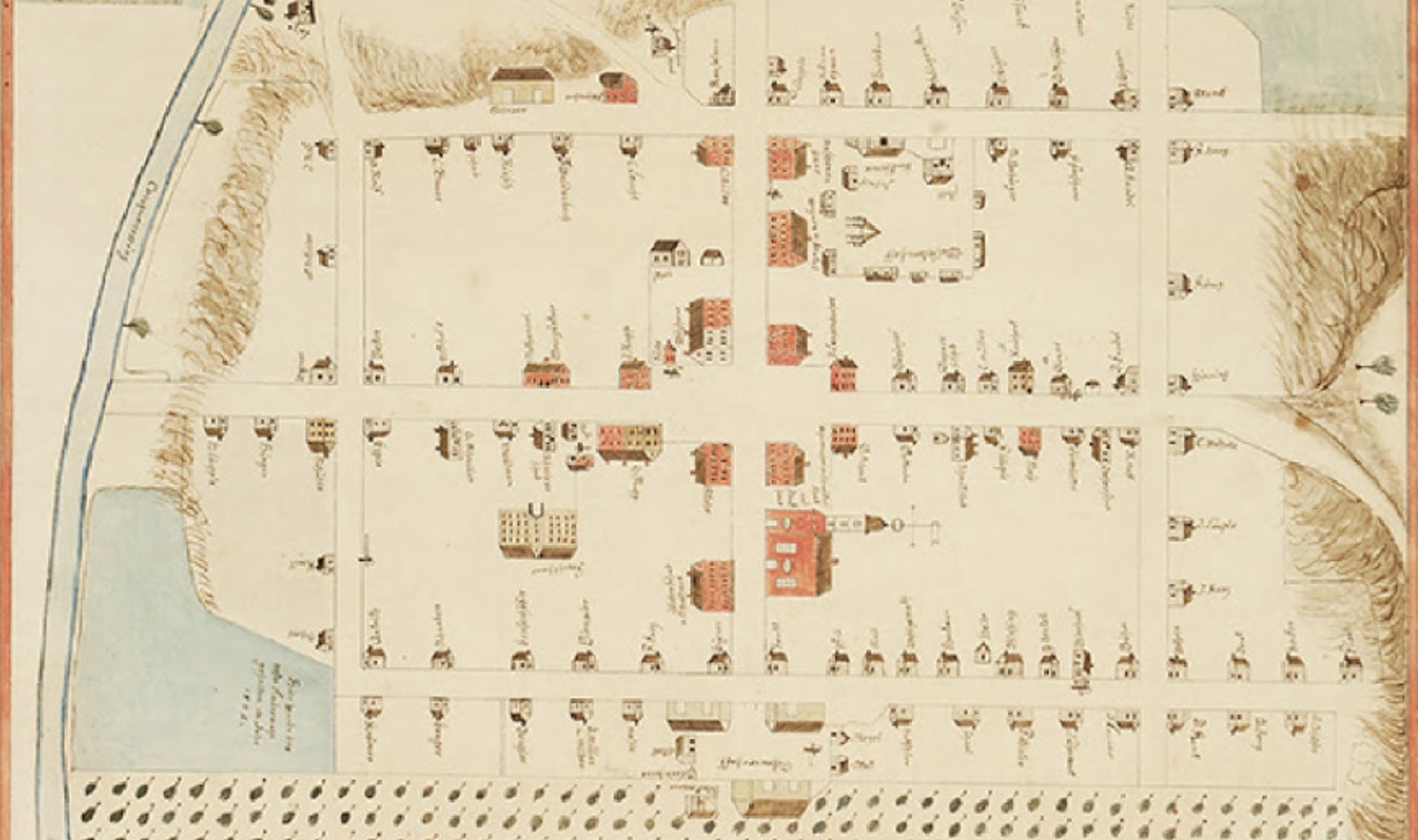
Even as these resources make it easier for curious newcomers to study old maps, printed books are still valuable, for they provide narratives of the history of American maps and exploration. Some of the same graphic technologies that have made map Websites possible have improved the quality of color reproductions on paper. Mapping a Continent is an exquisite coffee-table volume, 13.0 by 10.5 inches, entirely in color and on sale for a very attractive price. The quality of design and reproduction are superb; every tiny place name is legible, and key features are enlarged and discussed in sidebars.
Historical Atlas of North America, 1492-1814 is the book’s subtitle, but I think it is important to distinguish between two types of historical atlases. The first type is an atlas that depicts, on modern maps, the routes of exploration and migration, the changing boundaries and frontiers, the growth of railroads, highways, and cities. Because United States historiography and ideology has long celebrated westward expansion, this type of atlas has been popular for classroom instruction, often using a four-color, staple-bound Rand McNally edition. But this type of atlas fosters an illusion that the features of the continent were static, patiently waiting for European eyes and minds to discover and dominate.
Mapping a Continent belongs to a second type of historical atlas, which reproduces maps drawn by the explorers and cartographers of yesteryear, showing their conceptions of the world, their efforts to represent and mold the understanding of far-away places, based on their own travels or by collating the written and visual accounts of others. These atlases demand much more from their readers, who must retrain eyes accustomed to recognizing familiar shapes, and they reveal much more as well, for the ways that maps and boundaries failed to match actual landforms often had momentous historical consequences. Notorious cartographic fallacies such as the island of California or the inland sea dubbed the “Mer de l’ouest” by French cartographers are discussed in Mapping a Continent but so are lesser-known affairs. For instance, the 1763 Treaty of Paris and the 1783 Treaty of Versailles both provided that the western boundary of English and then United States territory would follow the middle of the Mississippi River, “from its source to the River Iberville, and from thence, by a line drawn along the middle of this river, and the lakes Maurepas and Pontchartrain to the sea” (245). New Orleans and environs thus lay on an island—bisected by the Mississippi—which lay in French and later Spanish territory. But contrary to its depiction on many French maps, the “River Iberville” (now known as Bayou Manchac), was barely navigable and actually dried up in some seasons. Merchant vessels sailing out the mouth of the Mississippi had to pass by New Orleans, in potentially hostile territory. This led Thomas Jefferson to bargain with Napoleon to buy the “island” of New Orleans, and in the negotiations, he was able to strike a deal for the entire Louisiana Purchase.
The distinction between the two types of historical atlas is analogous to the difference between a literary history and an anthology of excerpts or between a historical monograph and a casebook of documents. Anthologies and literary histories are often devoted to defining and celebrating a national literature. Cartography has always been an international endeavor; great cartographers such as Jean-Baptiste Franquelin did not restrict themselves to maps of their native land. Even so, collections of maps can serve a nationalist purpose, and in this volume, published in collaboration with the Bibliothèque et Archives nationales de Québec (home of many of the original maps), the “nation” of interest is Québec. Early chapters emphasize the explorations of Newfoundland and the Gulf of St. Lawrence by cod fishermen and the founding voyages of Jacques Cartier and feature stunning works such as a 1542 map by Jean Rotz of Dieppe. U.S. readers will find a new perspective on colonial founders. John Smith was “a braggart, a teller of tall tales, a compulsive liar” (66), whereas Samuel de Champlain published “drawings and maps that were more detailed than anything previously produced on North America” (83). George Washington’s map of the site of Fort Duquesne arises in connection with his responsibility for the killing of Joseph Coulon de Villiers de Jumonville in 1754. The conquest of Québec in 1759 is an important turning point in the narrative. A fine chapter on Lewis and Clark emphasizes how they relied upon French guides and maps.
![Universalis cosmographia secundum Ptholomaei traditionem et Americi Vespucii alioru[m] que lustrationes, Martin Waldseemüller, (1507). This digital image is a composit map (128 x 233 cm.) from twelve separate sheets (46 x 63 cm. or smaller). Courtesy of the Geography and Map Division of the Library of Congress, Washington, D.C. Click to enlarge in new window.](https://commonplace.online/wp-content/uploads/2016/01/9.2.Sayre_.2.jpg)
Because Mapping a Continent (published simultaneously in French as La mésure d’un continent) emphasizes French colonial regions, there’s little on Spanish exploration of the interior West by Coronado, Cabeza de Vaca, Escalante, or Father Kino. It is instructive to compare the book to its most recent competitor, America Discovered: A Historic Atlas of North American Exploration (2004) written by Derek Hayes of Vancouver, British Columbia, and published by a leading Anglo-Canadian publisher, Douglas and McIntyre. Hayes devotes more space to the Spaniards, to the West Coast, and to explorers of the English colonial Southeast such as John Lederer and Thomas Nairne. For Hayes “the fall of Québec in 1763” (130) inspires no elaboration, and the photo credits list no maps from the national library of Quebec.
A historical atlas of America is an essential reference for scholars who wish to understand nationalism or regionalism (such as in Québec) or even continentalism. At the beginning of Mapping a Continent is an exquisite T-O map from a 1460 manuscript depicting the biblical division of the world between Shem, Ham, and Japheth. Less than fifty years later, Martin Waldsemüller’s map was the first to name as “America” the new fourth continent. This map (shown here) was purchased by the U.S. Library of Congress in 2001 for $10 million, a cost justified, perhaps, by the need for the United States to lay claim to “America.” For just $59 one can own a fine reproduction of this and hundreds of other beautiful maps of the continent.
Further Reading:
Earlier historical atlases of the second type include Adrian Johnson, America Explored (New York, 1974) and Cumming, Hiller, Quinn, and Williams, The Exploration of North America, 1630-1776 (New York, 1974). The best atlas of the first type in my opinion is Goetzmann and Williams’s Atlas of North American Exploration (New York, 1992). Recent scholarship has emphasized the role played by Native American informants and mapmakers, for example in Mark Warhus, Another America: Native American Maps and the History of our Land (New York, 1997) and G. Malcolm Lewis, ed., Cartographic Encounters (Chicago, 1998).
This article originally appeared in issue 9.2 (January, 2009).
Gordon Sayre is professor of English at the University of Oregon and a specialist in French and English colonial literature of North America. He is coeditor of the manuscript memoir by Dumont de Montigny, Regards sur le monde atlantique, 1715-1747, published by Septentrion (2008).