The Pacific Ocean and eighteenth-century French imperial policy
If pressed, most early modern historians would probably identify the Pacific Ocean in the centuries between Magellan and Cook’s famous voyages as an area of marginal importance: the site of an interesting but relatively insignificant commerce between Acapulco and Manila from 1565 to 1815; of picturesque but largely inconsequential episodes such as Drake’s epic circumnavigation of the 1570s; and of idyllic but isolated archipelagoes, the existence of which long remained unknown to those who did not enjoy the good fortune of having been born there. From this perspective, the Pacific was a region tenuously connected to other parts of the globe, doing little to shape developments beyond its shores, offering little to historians seeking explanations for events in other areas. The first burden, then, for scholars interested in the early modern Pacific is to demonstrate the historical significance of the subject.
This is especially true for historians of the French Empire in the 1700s. Eighteenth-century France lacked long-established colonies in the Pacific Basin and thus one obvious connection to the South Sea; and even though French mariners such as Bougainville succeeded in the 1700s in overcoming the considerable challenges of Pacific navigation, they have often received less credit for their achievements than their more celebrated British counterparts.
Yet clusters of French merchants, officials, geographers, and savants directed their attentions or their ships to the Pacific throughout the eighteenth century, and their interest and activities helped to give the Pacific Basin’s lands and waters a more influential role in the period’s history than is widely appreciated. This essay will discuss two examples of this historical significance of the Pacific Ocean for the eighteenth-century French Empire. The first considers the manner in which French concerns about British expansion into the Pacific helped to draw France into the Seven Years’ War. The second uses an analysis of French assessments of the possibility of reaching the Pacific by means of some kind of water route through North America to help explain the French decision to cede western Louisiana to Spain at the end of the Seven Years’ War. These considerations influenced momentous French imperial decisions made half a world away from the South Sea, decisions that cannot, in fact, be fully explained without consideration of the Pacific horizons of eighteenth-century French thought.
I.
It will be useful, first, to mention the matter pertaining to the Pacific that exercised the earliest and most immediate influence on French merchants and officials. From the 1690s until 1763, the commodity drawing the attention of French merchants and officials to the Great South Sea was Spanish silver from the famous mines of Mexico and Peru. Most of this silver moved east across the Atlantic to Europe, but a significant portion went in the opposite direction, west across the Pacific to the Philippines, as part of the annual galleon trade that Spain conducted between Acapulco and Manila. American silver supported Spanish outposts in the Philippines, and vast quantities of it were exchanged there each year for East Asian products such as silk. Besides crossing the oceans in Spanish galleons, some New World silver remained, for a time at least, in the hands of the inhabitants of Spanish possessions in places such as Chile, Peru, and western Mexico. Numerous, poorly supplied with Spanish goods, and able to pay for the products of Spain’s competitors with bullion, these Spanish-American consumers on the Pacific Coast represented an irresistible market for countries such as France and Britain. Overall, Spanish America accounted for roughly 90 percent of world silver production in the eighteenth century; and because much of the remaining 10 percent occurred in Japan, to which Europeans had only the most limited access, Spanish America formed the essential source of silver for European traders and governments who wanted it.
And they did want it. The value of silver for individual Europeans was obvious and longstanding: it meant wealth. For governments, it meant not just wealth, but also power. Silver could be used to build ships, to pay soldiers, to back paper money—especially in wartime when the reliability of paper currency could easily become uncertain—and, perhaps most strikingly, silver could be used to buy the assistance of allies and the services of soldiers on the continent of Europe. Historian Fernand Braudel offered one telling example of this when he observed that the down payment on Britain’s alliance with Prussia in 1756 was thirty-four wagons of silver bouncing down the roads to Berlin. European statesmen keenly felt the importance of gaining supplies of silver for their own state, and of keeping large quantities of it out of the hands of their rivals.
Silver’s importance extended beyond the realm of power politics. It was, in fact, becoming increasingly important in eighteenth-century Europe because of its essential role in Europe’s growing trade with China. One aspect of Europe’s consumer revolution in this period was a burgeoning demand for goods such as Chinese porcelain, silk, and tea. The problem for European merchants was that in the years before they began exploiting the commercial possibilities of otter furs and opium, Europe had very little that China wanted to buy. Chinese traders did want silver, however, silver serving as the official means of exchange in China and as the currency in which the Chinese government insisted that taxes be paid. Any European government hoping to profit from trade with the rapidly expanding population of China had to find a source of silver with which this commerce could be conducted.
Spanish America offered the obvious answer to European statesmen and merchants. The question was how a European empire such as that of France could obtain it. The usual method was to exchange French goods for Spanish silver in Spain. This was much better than nothing, but because Spanish ships served as the conveyors, and Spanish merchants the middlemen between Europe and Spanish America, French merchants lost out on much potential profit. A second, more violent and direct method involved sending privateers or naval squadrons to seize Spanish ships and to attack Spanish cities on the Atlantic and Pacific shores of this Americas. Such attacks could bring spectacular results: English ships, for example, succeeded in taking Pacific galleons in 1587, 1709, and 1743.
Pirates, of many national origins, provided another example of this most straightforward way of trying to acquire the wealth of the Spanish Indies. In the last decades of the seventeenth century, impelled by the efforts of the European empires to reduce piracy in the Caribbean, and attracted by the temptations of poorly protected Spanish towns and shipping, packs of buccaneers journeyed into the Pacific by crossing the Isthmus of Panama and by sailing around the tip of South America. After enduring numerous costly attacks, Spain’s Pacific colonies finally succeeded in the 1690s in driving these pirates away. Some of the buccaneers made it back to Europe, however, where they recounted fabulous tales of Spanish wealth that naturally inflamed the avarice of their countrymen in French port towns such as St. Malo. Tales of treasure in St. Malo predictably reached the ears of officials in Paris, officials perpetually beset by the challenge of financing Louis XIV’s quest for military and courtly grandeur.
The combination of the experience of these pirates and the disruptions to the Spanish government and the Spanish shipping system during and after the War of the Spanish Succession suggested to French officials and merchants a third method of acquiring Spanish American silver, one that avoided the uncertainties and dangers of outright pillage; namely, direct trade between French ports, especially St. Malo, and the inhabitants of Peru and Chile. According to the treaties, precedents, and claims established during the early decades of the Spanish Empire, the Pacific was considered to be a Spanish Lake, a mare clausum from which non-Spanish shipping was excluded; pirates and privateers aside, this principle was generally accepted. But once the War of the Spanish Succession began in 1702, Spain’s naval forces proved insufficient either to protect Spanish commerce from English and Dutch raiders or to supply Spain’s distant colonies. French merchants eagerly took advantage of these Spanish difficulties by sailing directly to Peru and Chile themselves. Historian Carlos Daniel Malamud Rikles has estimated that between 1702 and 1713, ninety-eight French ships arrived in the Pacific. The merchants of St. Malo took on the most active role in the trade, and their passage through the South Atlantic left the Malvinas (Falkland) Islands with one of their two names.
Though it is impossible to arrive at precise figures, it is certain that the quantities of bullion returned to France from this trade were enormous. The Swedish historian E. W. Dahlgren—the author, between 1905 and 1913, of the fundamental works on the French presence in the early eighteenth-century Pacific—estimated conservatively that French ships involved in the Pacific trade in the early decades of the eighteenth century brought at least two hundred million livres of silver back to France. To view this in perspective, estimates put the total value of silver coinage in France in both 1683 and 1700 at five hundred million livres. More recently, historians such as Malamud Rikles and Stanley and Barbara Stein have offered estimates ranging between fifty-five and ninety-eight million pesos. To get a sense of the magnitude of these peso figures, consider that Alexander Hamilton estimated that the total value of both specie and paper money in the thirteen colonies on the eve of the American Revolution was about thirty million pesos. In short, access to the Spanish Pacific could result in staggering profits.
Such dividends brought their own difficulties. Spanish officials complained about the economic exploitation of their empire by French interlopers. British merchants and officials noted the profits French ships were bringing back from the Pacific, and, as the founding of the South Sea Company in 1711 attested, they wanted their own share of Pacific markets. It became clear to the governments of both the French and the British Empires during the peace negotiations at the end of the War of the Spanish Succession that neither would tolerate the presence of the other in the Pacific, and that therefore the only way to secure peace between them was to resume the traditional exclusion of all non-Spanish shipping from the South Sea. Spain, France, and Britain agreed to this, and thus, in theory, the diplomatic settlement at Utrecht precluded direct British or French involvement with the Pacific. Practice would not always conform to theory, however.
II.
With one of the fundamental reasons for eighteenth-century French interest in the Pacific in view, it now becomes possible to assess the implications of this interest through consideration of two instances of French governmental conduct. The first of these concerns French reactions to two British expeditions, in 1742 and 1747, that sought a Northwest Passage from Hudson Bay.
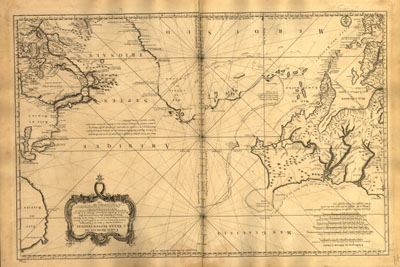
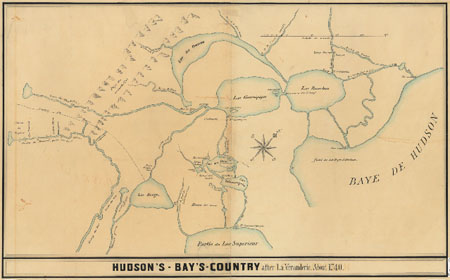
Large parts of the western shore of Hudson Bay remained unexplored by Europeans before the 1740s, making it possible for geographic speculators and promoters to imagine a passage extending from the bay to the warmer waters of the South Sea (see figs. 1 and 2 for two mid-eighteenth-century French views of the Hudson Bay region and its possible connections to the rivers of the North American West.)
One such promoter, Arthur Dobbs, a rich Ulster landowner, a member of the Irish parliament, and a future governor of North Carolina, succeeded in the 1740s in bringing about one government-supported and one privately-financed expedition to seek a Northwest Passage. French agents in London and French geographers at home reported on these British expeditions, and in the years after the end of the War of the Austrian Succession in 1748, officials in the French government began to assess the wider significance of these British ventures.
French officials were skeptical about the existence of a useable Northwest Passage from Hudson Bay, but their ignorance of the region’s geography left them feeling uneasy. They respected the prowess of the British navy, and they feared that the British, during the long decades of the Hudson Bay Company’s trade in the region, might have found evidence concerning a Northwest Passage that remained unknown to other Europeans. Moreover, French diplomats and ministers found it difficult to believe that the British Empire would be sending costly and dangerous expeditions into the icy waters of Hudson Bay without some plausible expectation of profit or advantage. For even the most dubious French observers, the very improbability and audacity of British exploration in the forbidding subarctic environment of the bay demonstrated the lengths to which the British would go in an attempt to reach the more alluring waters of the South Sea.
Two issues, in fact, troubled French officials evaluating 1740s British exploration in Hudson Bay. The first was a possibility with potential consequences for British naval capabilities; that is, that the British might find a new route to the Pacific that would then facilitate British trade with western America and East Asia, or British attacks on Spanish commerce and possessions. This possibility constituted a potential threat to the sale of French goods in Spanish America. The second issue was a certainty that elucidated British imperial intent. Whether or not they could find a practicable Northwest Passage, British explorers had unquestionably been looking for one. This seemed undeniable evidence that the British Empire was seeking new ways to reach the Pacific Ocean and the Spanish American markets along its shores.
Such evidence pointed to unsettling conclusions about the development of British policy since the 1713 Treaty of Utrecht. If, despite venerable, generally accepted prohibitions, the British were trying to find a new route to the Pacific through Hudson Bay, French officials could reasonably conclude that the British Empire must be willing to ignore the clause of the Treaty of Utrecht that prohibited British navigation in the South Sea. British conduct elsewhere seemed to support this conclusion, for exploration in Hudson Bay was only one of a group of British actions in the 1740s and early 1750s—including a British expedition into the Pacific from 1740 to 1744 (during the Anglo-Spanish War of Jenkins’ Ear) that sacked a Peruvian city and seized the Manila galleon off the Philippines; the continued presence of British log cutters in Honduras; planned British expeditions around Cape Horn in the late 1740s; and the publication in 1749 of a French translation of a book by a prominent British admiral advocating British expansion into the South Sea—that seemed directed at the Pacific. Together, this collection of British activities involving Hudson Bay, Central America, and Cape Horn persuaded French officials of the existence of a British plan for maritime expansion into the Pacific Basin. To French ministers and diplomats, the logical targets of such Pacific expansion were Spanish imperial territories and Spanish American silver, and these British moves towards the Pacific seemed indeed to indicate the existence of a broad British effort to secure the Spanish American wealth that Spain’s European rivals had coveted for so long.
When French officials in the early and mid-1750s considered British activities in other parts of the Americas—activities more familiar to American historians involving the Ohio Valley, Acadia, and the Caribbean island of St. Lucia—they had this larger, menacing British design very much in mind. They tended to interpret British expansion in contested regions of North America as part of a larger British effort to remove the French obstacle to British domination of Spain’s American empire. Consequently, French officials reacted pugnaciously to what otherwise might have seemed trivial instances of British aggression in marginal territories such as the Ohio Valley. These bellicose reactions contributed to the sequence of vigorous French and British measures and countermeasures leading to the Seven Years’ War.
III.
As French concerns about access to the Pacific shaped French imperial policy in the years leading into the Seven Years’ War, they also affected French decisions in the latter part of the conflict. This is evident in an examination of the relation between French assessments of the potential value of the French colony of Louisiana and the surprising French decision to cede the trans-Mississippi portions of the colony to Spain in 1762.
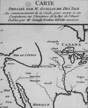
France founded the colony of Louisiana in 1699 and began serious efforts to develop it in the decade after the War of the Spanish Succession. From the beginning, colonizing the Mississippi Valley was difficult and expensive. The valley’s Indian inhabitants resisted French rule, its climate killed French settlers, its Spanish and British neighbors feared and opposed the colony, its budget absorbed French funds, and its administration frustrated Parisian ministers. Acutely aware of these difficulties, officials in Paris had always to consider whether the current, potential, and relative value of the colony justified the efforts and expenditures required to maintain it. Among the factors they evaluated were the fertility of the region’s soils, the character of its climate, the disposition of its Indian occupants, the likelihood of finding valuable mineral deposits, and the possibility of opening a lucrative commerce with the reputedly wealthy inhabitants of the Spanish colonies to the south and west. French officials also considered a more spectacular possibility; namely, that the western parts of North America that remained unexplored by Frenchmen and to which Louisiana offered access might contain a Mediterranean-like Sea of the West extending far into the continent, or a great River of the West flowing into this Sea or into the Pacific itself (see fig. 3 for one French vision of how the Sea and River of the West might look.)
The idea was that these conjectured features of western geography—lying, perhaps, just beyond a gentle plateau at the center of the continent—would offer a practicable water route to the South Sea beyond. Because, in the early decades of the eighteenth century, much of the Pacific Coast remained uncharted by Europeans, and awkward features of western geography such as the successive chains of mountains covering Idaho and western Montana remained unknown to them, the hopeful imaginations of French geographers and officials had room to roam.
Up until the middle of the eighteenth century, French officials, in the Ministry of Foreign Affairs, for example, took the possibility that western America would offer easy access to the Pacific quite seriously, and as a result, they attached a correspondingly elevated value to the colony of Louisiana. For if North America were permeable rather than impenetrable—if one could canoe, that is, more or less from New Orleans to Monterey—then Louisiana and the territories west of it could provide in time another way to get at the Spanish silver that had enriched French merchants and sustained the French government during the War of the Spanish Succession. This made Louisiana a colony to be monitored, developed, and kept.
A change of attitude away from this French official openness to the possibility of a practicable water route through North America began to become evident in the years around 1748. Between roughly 1748 and 1763 French foreign ministry officials appear to have grown increasingly skeptical about the possibility of French discovery and exploitation of a North American river route to the Pacific. In part this was because the French explorers who had long sought a passage to the Pacific from Louisiana and Canada, like the British explorers in Hudson Bay in the 1740s, had continued to fail to find one. In the aftermath of such failures, French cartographers who had placed northwest passages and seas and rivers of the west on their maps found themselves the targets of pointed criticism from their domestic and international colleagues and from the government officials who helped to finance the production of French maps. With exploration proving disappointing, and the most optimistic and speculative French cartography proving unreliable, it seemed increasingly logical for French officials to be skeptical about the existence of a useable water route to the West. In addition, the growing tensions and then outright war between France and Britain in the years between 1748 and 1763 made it necessary for French officials to take a hard look at the relative value of their overseas possessions not just on the continent of North America, but also in the Caribbean, India, and Africa. Under this kind of pressure, French officials tended in evaluating colonial value to emphasize known qualities of colonies—such as how much sugar an island produced—and to discount the potential but uncertain value of hypothetical features of western America geography.
When, at the end of the Seven Years’ War, a series of disastrous French and Spanish losses to Britain was forcing French officials to identify territories that could be ceded as the price of a peace settlement, the importance of the growing French skepticism about the existence of a practicable water route through the West became evident. If trans-Mississippi Louisiana offered such a route to the Pacific, it constituted territory of enormous potential value, but French officials seem by 1762 to no longer have thought of the colony in those terms. They saw it as an expensive and difficult-to-defend colony of limited economic value, not as the road to the South Sea. This helped to make western Louisiana expendable. France ceded it to Spain in November 1762, thereby ending the French Empire in North America. While to the contemporary observer looking back at the event it might seem hard to imagine that French concerns about access to the Pacific could figure in a decision to give up territory in the Mississippi Valley, historical investigation reveals the extent to which a choice made in Paris regarding a colony in North America was entangled with eighteenth-century French notions about the South Sea.
IV.
The two cases discussed above give some indication of the significance of the Pacific Ocean and routes to it in roughly the first two-thirds of the eighteenth century. Historians such as John Dunmore have shown that French interest in the South Sea continued in the years after 1763, but that in many cases this interest arose for different reasons. Some discussion of those reasons will provide a more complete picture of the relation between France and the distant Pacific in the eighteenth century as a whole, and of the way in which this relation developed over time.
The kinds of economic and geopolitical concerns discussed for the pre-1763 period did not disappear after the Seven Years’ War. They remained important for the French Empire in later decades. Louis de Bougainville, for example, established a short-lived French colony of Acadians on one of the Falkland Islands in 1764, in part to give France a foothold on islands that could serve as a naval station for future voyages to the Pacific, in part to compensate France for the territories recently lost in the Seven Years’ War. After Bougainville’s later circumnavigation of the globe from 1766 to 1769, French reactions to his account of Tahiti included a consideration not only of the character of the island’s inhabitants, but also of the potential uses of the island as a port of call for French ships making the long voyage across the ocean. Louis XVI sent the French explorer La Pérousse on his ultimately fatal Pacific expedition of 1785 to 1788 in part to counter British pretensions to naval supremacy and British ambitions in the North American Pacific Northwest.

Economic concerns remained vigorous as well. The instructions to La Pérousse, for example, directed him to look for opportunities for profitable commerce in the Pacific. Planners of his expedition had also given some consideration to using it as a means to initiate French fur-trading operations in the Pacific Northwest. (As a side note, the Northwest Passage, despite the disappointments of the previous four decades of exploration, was also an object of investigation for the La Pérousse expedition.)
On the whole though, the differences between the pre- and post-1763 periods are more striking than the similarities. One crucial difference was that the Spanish pretension to a monopoly of Pacific navigation broke down in the decades after 1763. The Spanish government, for example, even agreed to offer assistance to the La Pérousse expedition; and, less amicably, in the later 1790 Nootka Sound Convention, Spain conceded British access to parts of the Northwest Coast as yet unoccupied by the Spanish Empire. A second difference was that science, in the broadest sense of the term, became an increasingly salient aspect of French activity in the Pacific in the decades after 1763. This included French anthropological interest in the peoples and customs of islands such as Tahiti, famously exemplified by Diderot’s Supplement au Voyage de Bougainville and its reflection on tolerance, sexuality, and the moral worth of natural man; geographical interest in the possible existence of a vast southern continent, the search for which played an important role in the expeditions of Bougainville, Surville (1769-70), and Kerguelen (in the Indian Ocean, 1771-72, 1773-74); and competitive interest in keeping up with the scientific achievements of British figures such as Cook and Banks.
Before 1763, the Pacific had remained the presumptive preserve of Spain. Though it was becoming increasingly difficult to keep the ships of other European empires out of it, the Pacific could still be considered a realm apart. Consideration of the potentially serious commercial and geopolitical consequences of France or Britain breaking into the Spanish Lake animated French assessments of issues in some way connected to the South Sea. After 1763, it was becoming clear that the traditional isolation and exclusivity of the Pacific could not and would not be maintained. France moved from acting alternately as aspiring South Sea intruder or fretting Pacific gatekeeper to becoming, along with economic competitors and sometime scientific collaborators such as Britain, Russia, Spain, and the United States, one nation among many contributing to the increasing intellectual, economic, and political integration of the Pacific Ocean into the larger global community.
Further Reading:
Parts two and three of this essay present condensed versions of arguments appearing in my “French Reactions to the British Search for a Northwest Passage from Hudson Bay and the Origins of the Seven Years’ War” Terrae Incognitae 33 (2001): 13-32; and “French Geographic Conceptions of the Unexplored American West and the Louisiana Cession of 1762,” in Colonial Louisiana: A Tricentennial Symposium (Baton Rouge, forthcoming). I thank the editors of both publications for allowing me to use material from my previously written articles. For its account of France and the Pacific after 1763, this essay draws from John Dunmore’s excellent Visions and Realities: France in the Pacific, 1695-1995 (Waikanae, New Zealand, 1997). The key books on France and the Pacific before 1763 are E. W. Dahlgren, Le Commerce de la mer du Sud (jusqu’à la paix d’Utrecht), vol. 1 of Les Relations commerciales et maritimes entre la France et les côtes de l’Océan pacifique (commencement du XVIIIe siècle) (Paris, 1909); and Carlos Daniel Malamud Rikles, Cadiz y Saint Malo en el comercio colonial peruano (1698-1725) (Cadiz, 1986). For a sampling of the many strong works on Spanish silver, see Stanley J. and Barbara Stein, Silver, Trade, and War: Spain and America in the Making of Early Modern Europe (Baltimore, 2000); Ward Barret, “World Bullion Flows, 1450-1800,” in The Rise of Merchant Empires: Long-Distance Trade in the Early Modern World, 1350-1750, edited by James D. Tracy (Cambridge, 1990); Richard Garner, “Long-Term Silver Mining Trends in Spanish America: A Comparative Analysis of Peru and Mexico,” American Historical Review 93 (1988): 898-935; and Geoffrey J. Walker, Spanish Politics and Imperial Trade, 1700-1789 (Bloomington, 1979). Accounts of French piracy in the Pacific include Peter Gerhard, Pirates of the Pacific, 1575-1742 (Lincoln, 1990), and Peter Bradley, The Lure of Peru (London, 1989). For an introduction to the Manila galleon, look to William Lytle Schurz, The Manila Galleon (New York, 1959). Important accounts of Britain and the Utrecht settlement can be found in Glyndwr Williams, The Great South Sea: English Voyages and Encounters, 1570-1750 (New Haven, 1997); and L.G. Wickham Legg, “Torcy’s Account of Matthew Prior’s Negotiations at Fontainebleau in July 1711,” English Historical Review 29 (1914): 525-32.
This article originally appeared in issue 5.2 (January, 2005).
Paul Mapp is an assistant professor of history at the College of William and Mary.