Baltimore | Boston | Charleston | Chicago | Havana
| Lima | Los Angeles | Mexico City | New Amsterdam | New Orleans
Paramaribo | Philadelphia | Potosi | Quebec City | Salt Lake City
Saint Louis | Santa Fe | San Francisco | Washington, D.C.
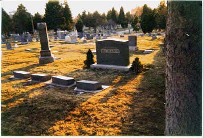
If a walk across the Brooklyn Bridge is the recommended introduction to New York City, a visit to the cemetery on the mountain side at Fourth Avenue and N Street is a good starting point for Salt Lake City. The cemetery began when one George Wallace, little known to history, buried his daughter Mary there in 1847, the first year the Mormons were in the valley. Two years later, Wallace joined Daniel Wells and Joseph Heywood in selecting twenty acres at the same site as the burying ground for the city. As a boy Richard ran about the cemetery when he visited his grandparents Willard and Hildegarde Lyman who lived just two blocks away. The grandparents are buried in the cemetery, and a few years ago, we received two plots as a Christmas gift. When the time comes, we will take our places high on the cemetery’s slopes.
If the inhabitants of the cemetery could see, they would look south over the Salt Lake Valley. Great Basin cemeteries favor places with grand prospects of land and sky, however desolate otherwise. From the cemetery, the Salt Lake Valley spreads out for fifteen miles between the mountains on the east and west and stretches twenty miles to the south. To the east, the first canyon piercing the wall of the Wasatch Mountains is Emigration. At the mouth, the “This is the Place” monument memorializes Brigham Young’s pronouncement when he came through in his wagon on July 24, 1847. By the end of that year, there were over fifteen hundred people planting homesteads in the desert.
Young was right; it was the place. The pioneers chose the best location for hundreds of miles in all directions. The Wasatch Front is a favored place in the Great Basin deserts. Here the sudden rise of a high range milks the clouds floating in from the Pacific. The runoff from the snow pack keeps water in the streams year around. Even so, like the Great Migration of the Puritans in the seventeenth century, the migrants to the valley in the nineteenth century were far more numerous than the natural attractions warranted. Had the Mormons not been seeking a refuge from the society that treated them so badly, the pioneers would have passed right on through to California or Oregon. Their religion not only brought them there, it enabled them to survive. Only a highly organized group could have cooperated in building the irrigation system that made farming possible. Many died lonely deaths along the trail. The lucky ones survived to end their earthly existences in the Salt Lake burial ground.
Far to the south of the cemetery, through the haze of smog that afflicts this cupped space when an inversion hangs over it, is the Point of the Mountain, where Salt Lake Valley blends into the next natural unit, Utah Valley. A wide opening at the point leaves room for the Jordan River to flow north from Utah Lake to its final destination in the Great Salt Lake. The three bodies of water are Utah’s equivalent of Galilee, Jordan, and the Dead Sea, except the direction of the Jordan’s flow is north rather than south. The name Jordan came naturally to the first settlers who thought of themselves as a restored Israel. To the west are the Oquirrh Mountains, bounding the western edge of the valley, and at their northern point is the silver streak that is the lake itself, a briny western sea with no outlet. To the north, the spur of the Wasatch Mountains on which the cemetery sits completes the cup that holds the city. Though it cannot be seen from the cemetery, the Utah State House modeled after the United States Capitol presides over the city from a promontory of the same spur, looking down on the temple and the headquarters of the Church of Jesus Christ of Latter-day Saints, its onetime rival and recurring source of irritation. When the cemetery’s dead rise at resurrection, they will see a geography implanted with the state’s early history spread before their eyes.
The cemetery looks down on the flat bed of what was once the huge inland sea known at Lake Bonneville, the valley floor where the original city was platted. The orderliness of the city becomes evident from this perspective. The exactly square, ten-acre blocks separated by streets wide enough for one to turn an ox team around without backing up are evidence of a practiced rationality. Salt Lake City is actually the fifth in the series of Mormon-planned cities that began with the “City of Zion” mapped out by Joseph Smith in 1833 for Independence, Missouri, followed by similar plats for Kirtland, Ohio; Far West, Missouri; and Nauvoo, Illinois. All the plats had perfectly square blocks and wide streets with central squares for a temple. Everyone was to live in the city on one-and-a-quarter-acre plots and go to their farms each day. In the Salt Lake Valley, Brigham Young copied Smith’s plan and then replicated it in Mormon villages up and down the Great Basin Kingdom from Idaho to Arizona.
The cemetery is situated in the section known today as “the Avenues,” a set of streets that climb up the steep mountain slope to the north of the city. On the Avenues everything is a little different. On the flat, a peculiar and highly rational street numbering system provides an exact reading of every site’s location on the ten-acre blocks. Early in the twentieth-century, a city engineer named Richard Lyman (yes, a relative) devised a baffling, but foolproof system for locating addresses on the valley floor. An address like 90 North 400 West seems to have too many elements, but these are exact coordinates, ninety units north of one meridian and four hundred west of another. The meridian lines in Salt Lake City are State Street (running north and south from the capitol) and South Temple Street (running east and west along the southern edge of Temple Square). That symbolic pair—Temple and State—embodies the entire history of the city.
The Avenues depart from this system (as do the jumble of suburban developments to the south of the city in an abandonment of its glorious rationalist legacy). In the Avenues, the houses climb up the slope like the dwellings on San Francisco’s hilly streets, or they sit on the “beaches” that mark the various levels of old Lake Bonneville. The streets running perpendicular up the mountain are alphabetized rather than numbered. The blocks are smaller and the precise measurements that worked on the floor of the valley do not apply. Avenue houses were not intended to have large gardens like the houses on the flat. Opened up mainly in the last quarter of the nineteenth century, the Avenues were a real estate development for city residents, a departure from the original concept of urban farmers in the City of Zion. Streets were carved out of the mountainside by developers and individual lots flattened into stair steps marching up the hill.
When Richard’s grandparents moved into the house at 319 L Street above Sixth Avenue in 1901, Willard sold shoes on the road. A boy who came from the village of Scipio with seventy-five cents in his pocket was now in commerce rather than agriculture. The Lymans planted a cherry tree in the backyard but no orchard. The Avenues were an urban residential district, a sign that Salt Lake City was evolving into a modern city.
Salt Lake City’s cemetery was laid out when the garden cemetery movement was getting started nationwide, but for the first half century the cemetery could not have been much more than a bare, sun-baked, southern slope of the mountain, with nothing but a magnificent view. It blossomed only after 1900 when an irrigation system brought water from nearby City Creek Canyon. The Mormons had begun irrigation much earlier—on the first day in the valley. On the flat, water ran in all the gutters and property owners took their “turns” by inserting gates and diverting the water into their gardens. But for a long time the network of canals and ditches did not bring water to the Avenues’ slope, where the land was too steep for farming. Not until the real estate became valuable for city residences did the water engineers tap into City Creek high up on its course and bring the water along the mountainside to the houses and the cemetery. The water brought life to the slope—and sometimes death. Hildegarde Lyman saw a baby fall into an open ditch and drown right in front of her house. She ran out with bedding to dam the stream so that the body would not float on down the canal.
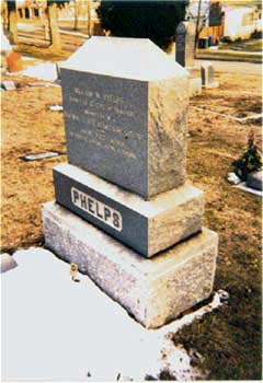
The cemetery holds over 115,000 residents, each one briefly telling his or her story on a stone. The marker of William Wines Phelps, a well-known name in Mormondom, rises in the southwest corner. Phelps, generally known as W.W., was one of a small number of educated people attracted to Joseph Smith. Joseph put him to work editing the Evening and Morning Star, the church newspaper published in the first City of Zion in Independence. Phelps helped Joseph’s wife Emma compile the church’s first book of hymns and wrote twenty-nine of them himself. One of them sung at the dedication of the first Mormon temple in Kirtland, “The Spirit of God Like a Fire is Burning,” has become a Mormon classic, the most popular of Mormon hymns along with William Clayton’s “Come, Come Ye Saints.” Clayton’s was a pioneer trek song; Phelps’s celebrated the spiritual triumph of temple completion. Engraved in the stone of his grave marker are the words of another of his hymns, “If You Could Hie to Kolob.” Kolob, in Mormon scripture, is the star closest to the throne of God. One of the verses (out of many in the original poem) on the tomb goes:
There is no end to glory; There is no end to love. There is no end to being; There is no death above.
The poem gives a hint of the mystery running through the Salt Lake streets like the water in the ditches.
Next to Phelps’s marker is the stone of Sally Phelps, his wife. According to the engravings, they were married for eternity in the Nauvoo temple on January 15, 1846, two of the thousands who went through the temple rites in the final months before the Mormons were forced to evacuate the city. After arrival in the Salt Lake Valley, one of Brigham Young’s first acts was to strike the ground with his cane and proclaim, “[H]ere we will build a temple to our God.” The great six-spired granite temple, which the Saints took forty years to erect, attracted converts from across the globe. Mormon scriptures turned the world into a great funnel drawing believers out of the world to Zion. The temple at the vortex was the magnet. The temple gave the Saints a vision of existence, as Phelps put it in another verse of his poem, with no end to matter, no end to space, and no end to spirit.
Making the temple square the meridian for the city was entirely fitting, but the cemetery tells another story. Not far from Phelps’s plot is the Catholic section of the cemetery and nearby are areas for the Jewish congregations B’Nai Israel and Montefiore. Another section holds people who died en route to the California gold fields, and there are places for the Japanese and the Chinese associations. The Mormon attempt to monopolize the history of the city is disrupted by these plots. They are a reminder that Catholic priests were the first Europeans to explore the Salt Lake Valley, and that the Mormons might not have survived if the Gold Rush pioneers had not paid high prices for produce to sustain them on their last leg of the California trek. Later the Chinese made the westward journey of Mormon converts infinitely more convenient by building the transcontinental railway.
Surprisingly, the arrival of diverse ethnicities and faiths did not roil the waters. The Mormons were hospitable to other denominations. When mines and railroad construction drew thousands of workers from all over Europe to the state, church leaders welcomed the religious congregations that sprang up. These laboring groups created their own centers—in Price for the miners and Ogden for the railroad workers—but many came to Salt Lake City. The large Roman Catholic Cathedral of the Magdalene rises on South Temple Street just a few blocks east of the Mormon temple on property Brigham Young helped the Catholics obtain in 1866. Although Latter-day Saints lay exclusive claims to being the one true church, they have been tolerant in practice. In Nauvoo, the city council, under Joseph Smith’s direction, passed a religious toleration statute, giving “Catholics, Presbyterians, Methodists, Baptists, Latter-day Saints, Quakers, Episcopals, Universalists, Unitarians, Mohammedans, and all other religious sects and denominations whatever” equal privileges. Young continued the policy in Salt Lake.
He was less sympathetic to evangelical missionaries who came to convert Mormons to Christianity, but the harshest conflicts came over politics and commerce. When the railroad was completed in 1869 at Promontory Point in Northern Utah, Brigham Young foresaw an influx of “gentile” merchants dominating trade and draining the Mormon settlements of scarce currency. There was a fear that extravagant living, especially in Salt Lake City, would corrupt Mormon virtue. In anticipation of the problem, Young advocated “retrenchment,” meaning conservative and inexpensive dress and less dependence on imported luxuries. After the railroad arrived, he organized a commercial operation, the Zion’s Cooperative Mercantile Institution, to keep the profits of trade in Utah. Willard Lyman was packing shoes for ZCMI when he met Hildegarde who was making overalls in the ZCMI factory. Young wanted to create a church economy inside of the larger national economy. This strategy, though fitting for his purposes, brought on endless disputes about Mormon monopolies. When national antipolygamy forces picked up steam, they had a ready-made band of allies within Salt Lake City.
Antipolygamists and opponents of theocratic government brought legislative pressure against Mormon marriage practices beginning with the 1862 Morrill antibigamy law. The church evaded enforcement of successive antipolygamy laws for two decades through cleverly devised court cases that defined plural “sealings” in the temple as something other than bigamy. But by the mid-1880s, as the legislative noose tightened, the Mormons ran out of arguments. Federal officers began to enforce laws against cohabitation. Polygamist fathers went into hiding, and their second families, sure evidence of plural marriage, had to be concealed. Hildegarde Lyman was taken out of school to hide with her baby brother Victor in an upper room. “I learned to love him dearly,” she later wrote. When her father was arrested for cohabitation anyway, she went to stand on the prison wall and look down at him in the prison yard dressed in a striped suit.
In 1890, the church president, Wilford Woodruff, announced that he was not authorizing further plural marriages. It took twenty years or more for the Mormons to extricate themselves from polygamy, but they finally did. It was a major step in bringing Salt Lake City into the larger economy and national politics. But it was only one step. The groundwork had been laid earlier. The ethnic and religious diversities in the cemetery suggest that by the end of the century Salt Lake was becoming a modern variegated metropolis, not just the “City of the Saints.” Construction on the surrounding Avenues made homes for modern city dwellers, not the urban farmers of the City of Zion. The strict rationality of Joseph Smith’s original plat was adapted to the demand for inexpensive city residences on small lots. The cemetery itself benefited from the water brought along the mountainside for the real estate development. With its grass and trees, the cemetery became a suitable resting place for middle-class Americans.
Further Reading:
The masterwork on Utah society and economy in the nineteenth-century is Leonard L. Arringon, Great Basin Kingdom: An Economic History of the Latter-day Saints, 1830-1900 (Cambridge, 1958). For a modern, bright history of the city see Thomas G. Alexander and James B. Allen, Mormons and Gentiles: A History of Salt Lake City (Boulder, Co., 1984). A more detailed view of the neighborhood is found in Karl T. Haglund and Philip F. Notarianni, The Avenues of Salt Lake City (Salt Lake City, 1980). Salt Lake City life is preserved in hundreds of diaries and reminiscences like the Lyman histories quoted here: “Willard H. Lyman: History and Life Sketches,” 1961, typescript, and “History and Reminiscences of Hildegarde Sophia Schoenfeld Lyman,” 1961, typescript, both edited by Cherry Bushman and in the authors’ possession.
This article originally appeared in issue 3.4 (July, 2003).
Claudia Bushman teaches American studies as an adjunct professor at Columbia University and is the author of In Old Virginia: Slavery, Farming, and Society in the Journal of John Walker (Baltimore, 2002). She is working on a study of Mormonism in America in the last quarter century for Columbia University Press.
Richard Lyman Bushman is Gouverneur Morris Professor of History emeritus at Columbia University. His most recent book is The Refinement of America: Persons, Houses, Cities (New York, 1992). Born in Salt Lake City, he is working on a biography of Joseph Smith.