Creative Commons license
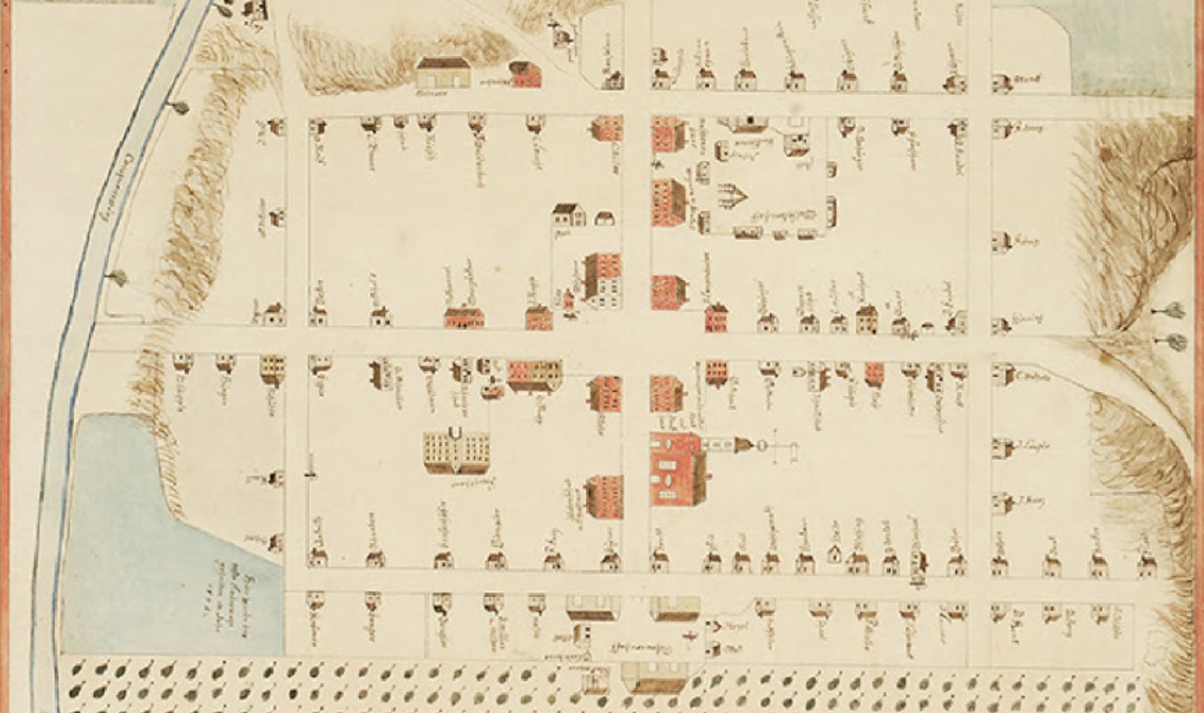
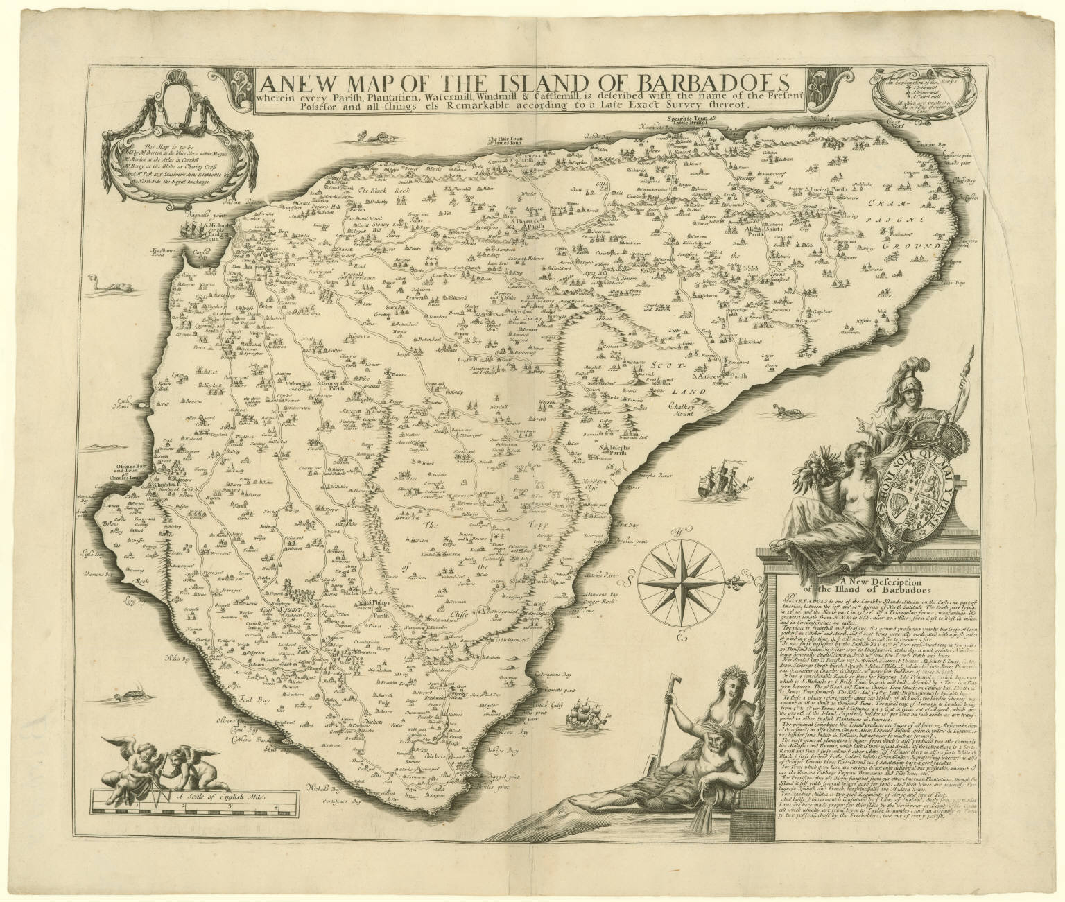
In the summer of 1680, the governor of Barbados, Jonathan Atkins, sent a chart of this “Caribby” island “Situate on the Easterne part of America” to the Council of Trade and Plantations in London. The copy he submitted is likely the one pictured here (Fig. 1), now in the Map Collection of the John Carter Brown Library at Brown University, Providence, Rhode Island. Entitled A New Map of the Island of Barbadoes wherein every Parish, Plantation, Watermill, Windmill & Cattlemill, is described with the name of the Present Possesor, and all things els Remarkable according to a Late Exact Survey thereof, the impressive cartographic image was drawn from a survey undertaken by the Bridgetown-based Quaker Richard Forde. Measuring roughly a half-meter squared, it shows the island fully inhabited and barely a patch uncultivated; the entire territory, criss-crossed by roads, is studded with English names and symbols marking plantation houses and mills. Even the title’s repetition of “mill” seems designed to propel our sense of the colony’s continuous, contiguous industry—all these mills being, as the key in the top-right corner explains, “imployd in the grinding of Sugar Canes.” By the 1660s, Barbados had become probably the most densely populated and intensively cultivated agricultural area in the English-speaking world, deeply interconnected with England’s other colonies in America and far beyond. In the early 1680s the free white population is estimated to have reached around 20,000; the enslaved black population, whose brutal forced labor supplied and worked the mills, outnumbered the whites by more than two to one. The violence, and indeed even the mere fact of slavery, is silenced by the map.
Looking at this peaceful, productive view alone, you would likewise never imagine that five years earlier, in August 1675, Barbados was hit by a devastating hurricane that reduced the machinery of the booming sugar industry to smithereens. “Never was seen such prodigious ruin in three hours,” wrote Governor Atkins in a letter to officials in London. A thousand houses, three churches and most of the mills on the west side of the island were destroyed, and hundreds of people were killed, “whole families being buried in the ruins of their houses.” The disaster went down in colonial history as one of the most dreadful events that ever happened to the island, which “changed much the face of the country.” The effects were exacerbated by the scale and density of the settlement by 1675, and by a hurricane the previous year that “whirled us like a top about all points of the compass” and did great damage. With each hurricane, the lack of shelter resulting from extensive deforestation left people, buildings and crops more vulnerable.
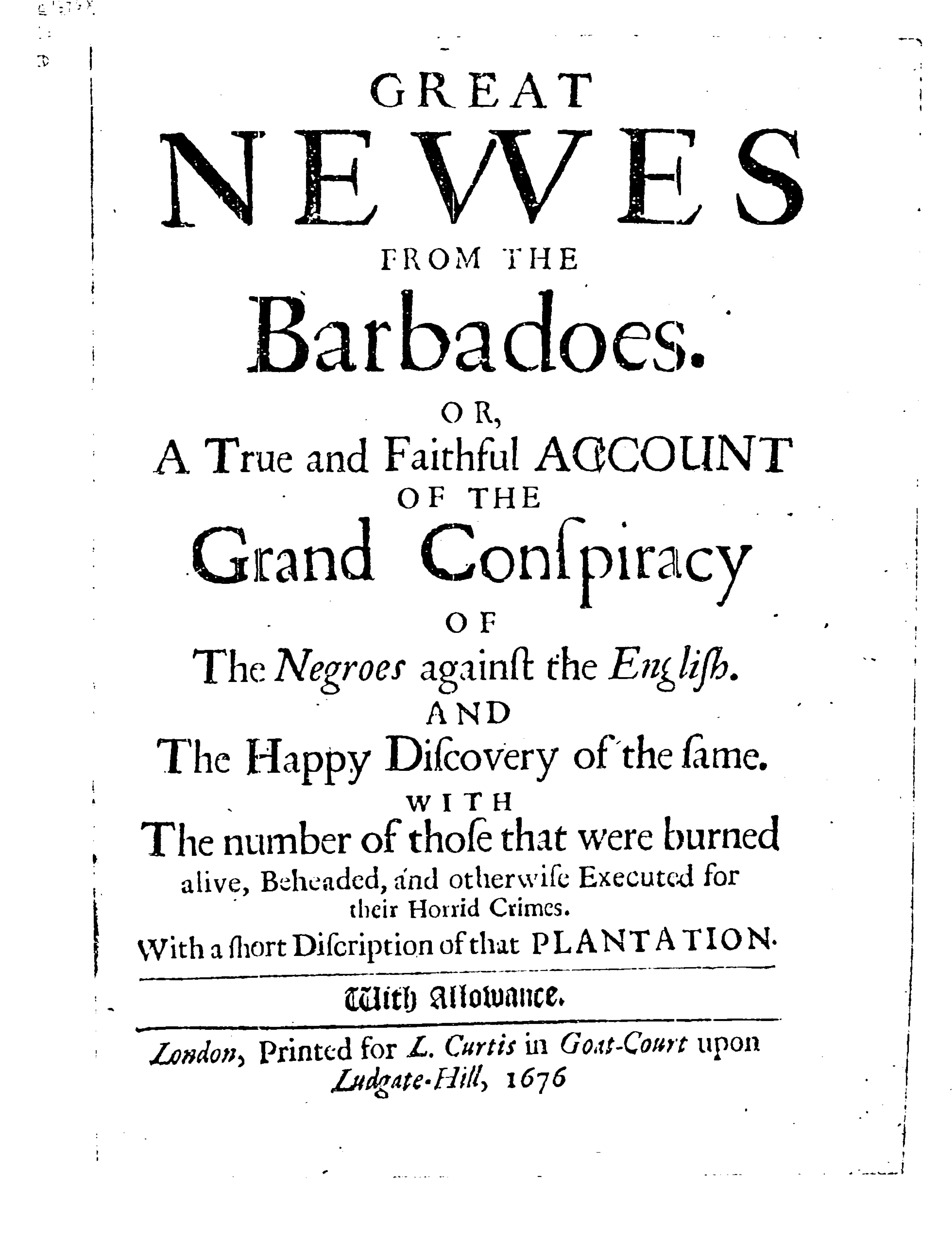
In transforming the physical landscape, the hurricanes also disturbed the stratified social landscape. Refusing to discriminate between free, indentured and enslaved, they tore down the built spaces that regulated and reinforced these differences. The literal and figurative levelling effect raised the idea, very dangerous to the interests of the colonial elite, that everyone was equal after all, and opened up space for resistance. An anonymous pamphlet published in 1676, Great Newes from the Barbadoes, Or, A True and Faithful Account of the Grand Conspiracy of the Negroes against the English (see title page in Fig. 2), exposes how the fear within the colonial elite elicited a murderous response to the threat of a slave rebellion: the title page highlights the number (at least 42) “of those that were burned alive, Beheaded, and otherwise Executed for their Horrid Crimes.” It is in the context of this brutal oppression, and the propaganda of the pamphlet—which concludes with the line that Barbados is “the finest and worthiest Island in the World”—that we should consider the map.
The picture of calamity, chaos and confusion conjured by textual descriptions of the successive hurricanes and their aftermaths is ostensibly countered by the map’s calm visual order (the note on climate in the “Description” mentions only the “fresh gales of wind” that relieve the heat of a typical day). Yet uncertainty over the print’s production, publication and reliability reflects the rupture, exacerbated by the distance of space and time between colony and metropole.
Forde appears to have drawn up the map (in draft form at least) by January 1675 and sometime afterwards sent it to England to be “perfected” and published. Yet there is evidence to suggest that, with his draft in effect torn up by the hurricane in August 1675, he was attempting to revise it according to new conditions in the summer of 1676 and perhaps even later. Meanwhile, the Lords of Trade were growing impatient at the “want of maps” they believed was hindering their administration of the colonies, and ordered all overseas governors to “send home maps of their plantations.” Atkins (and he was not alone) was slow to deliver. In 1679, four years after the initial request, he received a letter insisting that he despatch “what their Lordships have already demanded without effect, viz. description and map of the country which he promised to send in 1675.” When the map finally arrived in Whitehall in 1680, Atkins was not at all confident it served the purpose: “I have at last procured a chart of the Island, but I cannot commend it much,” he wrote; “that it is true in all particulars I cannot assume.” The disturbances and transformations incurred by the hurricane must in part account for those doubts—in addition to the Quaker surveyor’s deliberate omission (for religious reasons) of the word “church” and almost any sign of fortifications, the coverage and condition of which for the purposes of both internal and external defense were a prime concern of officials in London.
We do not know exactly what imperial officials thought of the map, but without close inspection they may have been pleasantly surprised and reassured by the handsome image. The print shown here was certainly added to the Office of Trade’s growing map library and today remains among a sampling of that once-extensive collection known as the Blathwayt Atlas (after the Office of Trade’s secretary William Blathwayt, who oversaw their acquisition in the 1670s and 1680s). The inclusion of Barbados, alongside maps charting an array of colonial and commercial settlements from Massachusetts Bay to Bermuda and Bombay, confirms the island’s importance within England’s expanding territorial interests through the seventeenth century, not just in the Atlantic region but around the world. Thanks to recent digitization by the John Carter Brown Library, it is now possible to view the Blathwayt Atlas maps online and to study individual items in minute detail—to see them both in context and close-up.
Scholars have stressed the importance of Forde’s work as the “first systematic” and “first economic” map of the island, but from such a perspective (like that of Governor Atkins) the details may disappoint, or indeed obscure. A prime purpose of the printed work, through its powerful combination of image and text, was to promote the colonial project and persuasively smooth over its challenges and contingencies, and the coercion at its core. That Forde’s map did so successfully for audiences in England is suggested by its continued use in different editions over a period of more than thirty years. With its simultaneous projection of progress and indeterminate history amid the hurricanes, the New Map of the Island of Barbadoes leaves us with a complex view of a colony—and empire—in the process of construction and reconstruction.
Further Reading:
The only full study to consider the significance of the maps as a collection is Jeannette D. Black’s The Blathwayt Atlas, 2 vols (Providence, RI, 1970-75). On Forde’s map (including the spelling of his surname, often given simply as Ford), see 180-85. See also P. F. Campbell, Some Early Barbadian History (St Michael, Barbados, 1993), 191-96. For a social and economic perspective that discusses the map in relation to a contemporary census, see Richard Dunn, Sugar and Slaves: The Rise of the Planter Class in the English West Indies, 1624-1713 (Chapel Hill, NC, 1972; repr. 2000), 84-116 (esp. 96-100), an expanded version of Dunn’s “Barbados Census of 1680,” William and Mary Quarterly, 3rd Ser., 26 (1969): 3-30. For a recent digital humanities approach, see Peter Koby, “The Modern Utility of Ford’s Colonial Map of Barbados, 1674,” Journal of Map and Geography Libraries 11, no. 1 (2015): 60-79. For introductions to demography, society and identity in Barbados within an early modern American context, see Dunn’s works above and Jack P. Greene, “Changing Identity in the British West Indies in the Early Modern Era: Barbados as a Case Study,” in Imperatives, Behaviors, and Identities: Essays in Early American Cultural History (Charlottesville, VA, 1992), 13-67. The correspondence between Governor Atkins and the Lords of Trade is recorded in the Calendar of State Papers, Colonial, America and West Indies.
This article originally appeared in issue 17.3 (Spring, 2017).
Dr. Emily Mann is a postdoctoral Research Associate with the Centre for the Political Economies of International Commerce (PEIC) at the University of Kent and, from September 2017, Early Career Lecturer in Early Modern Art at the Courtauld Institute of Art, University of London. She is working on an edited volume exploring the Blathwayt Atlas maps. emily.mann@courtauld.ac.uk