objects

Bad Maps, Courtroom Clashes, and Agrarian Life in 17th-Century New England

Even on the colonial periphery of a budding English cartographic culture, settlers used maps as tools to claim ownership and power.

image_pdfSave to PDFimage_printPrint

What makes a map “bad”? When I speak with friends or family members about my new book,  Creating New England, Defending the Northeast: Contested Algonquian and English Spatial Worlds, 1500-1700, they are often surprised by the “crudeness” of many of the maps I discuss. One person memorably commented, “It’s not much of a map.”

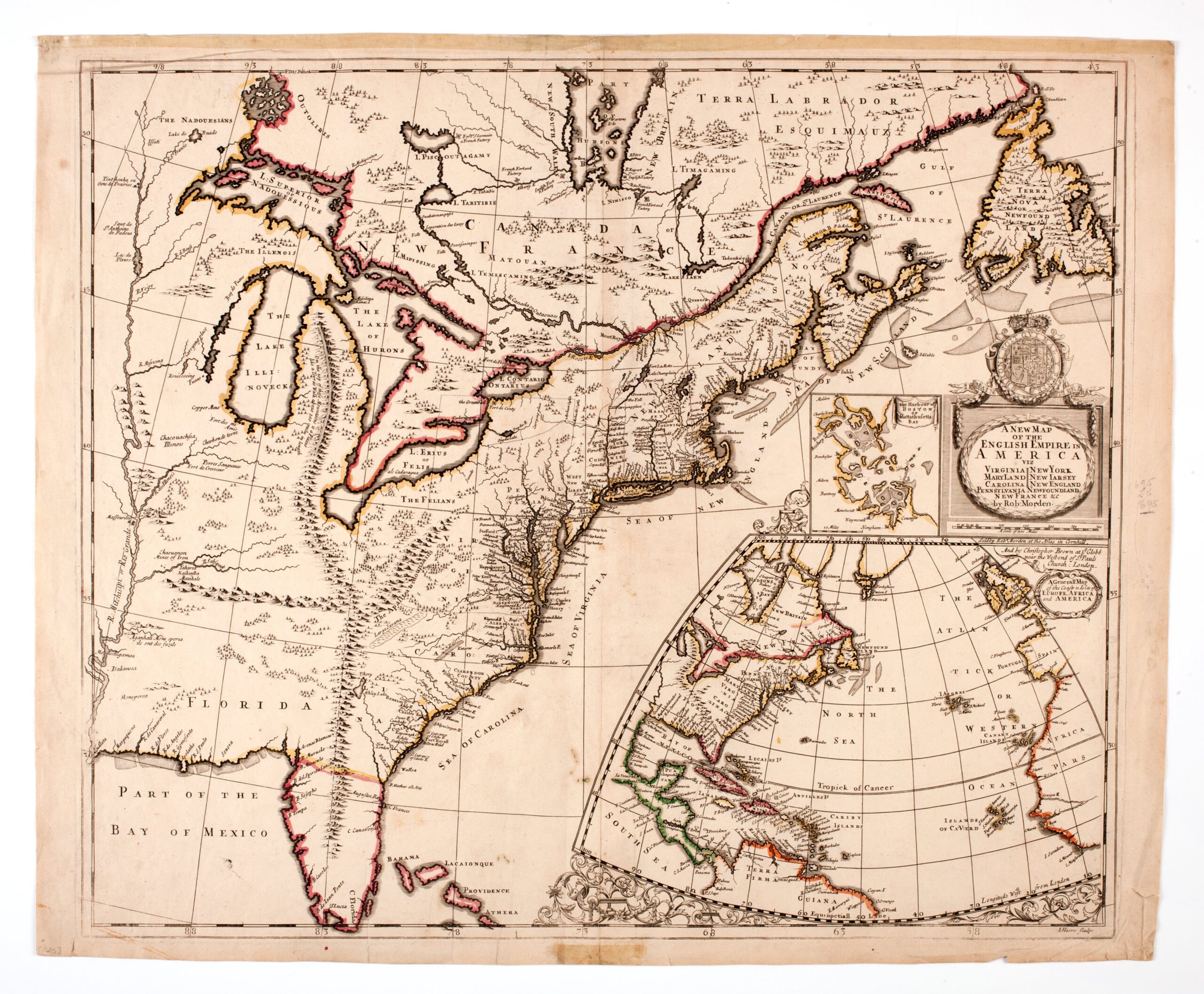
Instead, people expect pages replete with the elaborate cartographic constructions of famed mapmakers such as Robert Morden or Herman Moll. “Good” maps such as these are something that most of us can probably identify: From one perspective, they could be defined by their aesthetic qualities. Wealthy English landowners in the 1500s and 1600s wanted maps of their estates to hang on their walls, and colonial boosters showed off maps to convince people of the fertile landscape of North America. Alternatively, a map could be perceived as “good” inasmuch as it fulfilled its intended purpose. For example, a cadastral map that precisely showed borders often served as potent legal evidence in property disputes. And while some of the Indigenous and English-made maps I examine in my book had aesthetic value or obvious functionality that made them “good” maps, others made by colonists did not. In the 1660s and 1670s, colonial farmers hastily—and frankly clumsily—sketched collections of lines to portray local borders. I argue in my book that these sketches constituted the emergence of an awareness of maps as a useful tool (“map mindedness”), though their usefulness is less apparent; these maps seem to have not been particularly well suited to agrarian, cadastral, or legal purposes.

Figure 1: Robert Morden, A New Map of the English Empire (London: Robert Morden, Circa 1695). Courtesy of American Antiquarian Society.

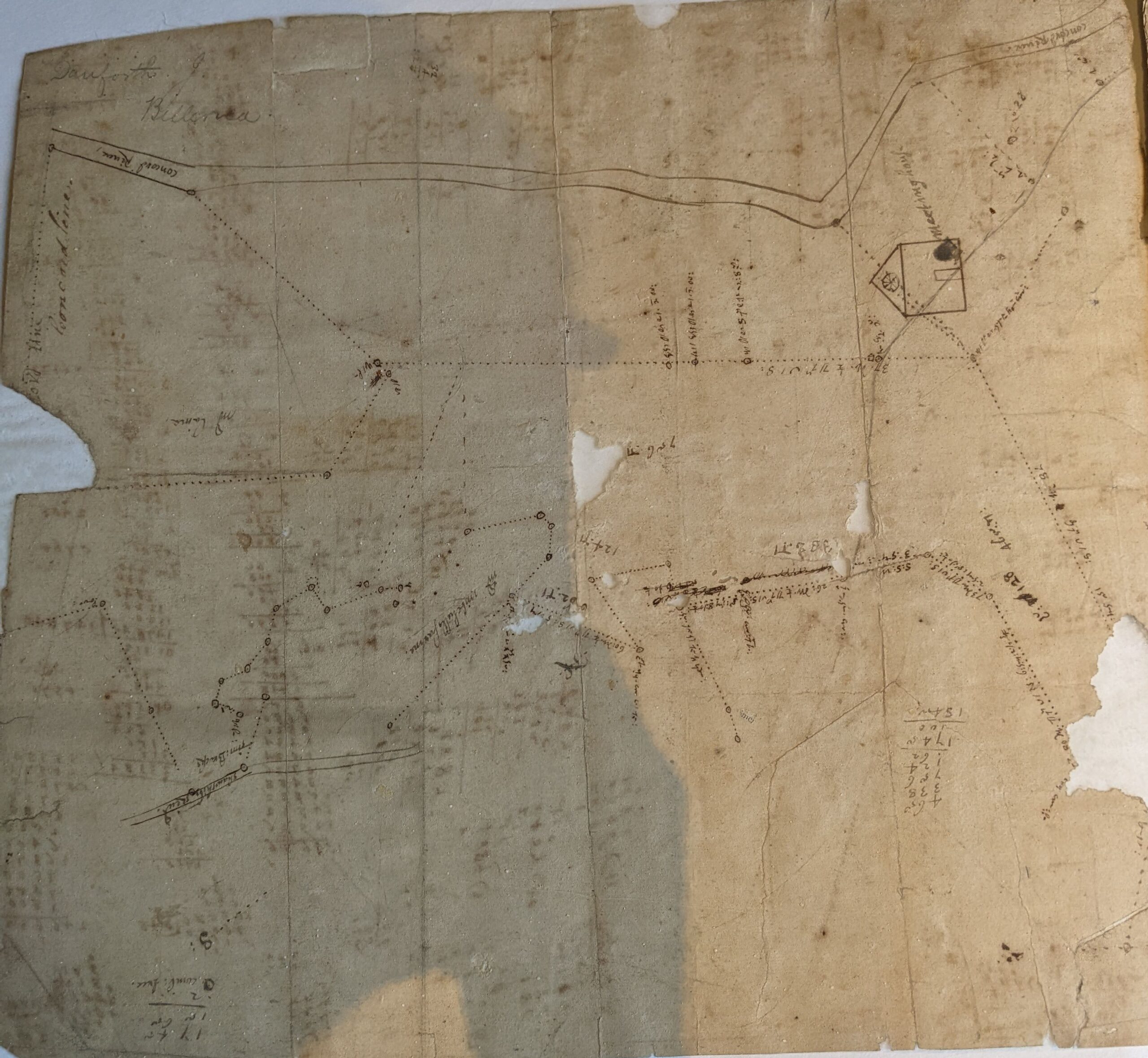
The spatial culture of English colonists in the Northeast underwent major changes in the 1660s and 1670s. Colonists, buoyed by military victories over their Algonquian neighbors and a sense of political domination, sought to transform the Northeast into something more familiar to them. As they cut back forests, filled in swamps, built roads, and left marks of their English culture on the land, they increasingly employed surveyors and “artists” to describe it in an English manner. By the 1650s, these “artists,” trained in mathematics and drafting, traced some of the first survey maps of the region, generally when legal conflicts over borders emerged between towns or colonies. For colonists, these top-down visualizations were new. Previously, they had almost exclusively characterized landscapes (including borders) through written descriptions that mirrored perambulation. Perambulations were a traditional activity in English society in which communities would come together and walk around boundaries, noting important markers for future recollection, sometimes through mnemonics. In New England, town governments appointed local men to write accounts of walking past landmarks, including marked trees, rocks, stakes, roads, fences, and bodies of water. The subjective experience of the perambulator expressed in the document offered an eye-level perspective of traveling through the land; Such accounts centered the passage of time, as each sentence listed a new feature sequentially, mirroring the activity itself.

Figure 2: Jonathan Danforth, [Manuscript Plan of Town of Billerica], 1658, Massachusetts Historical Society, Mss. Large 1658. Collection of the Massachusetts Historical Society.

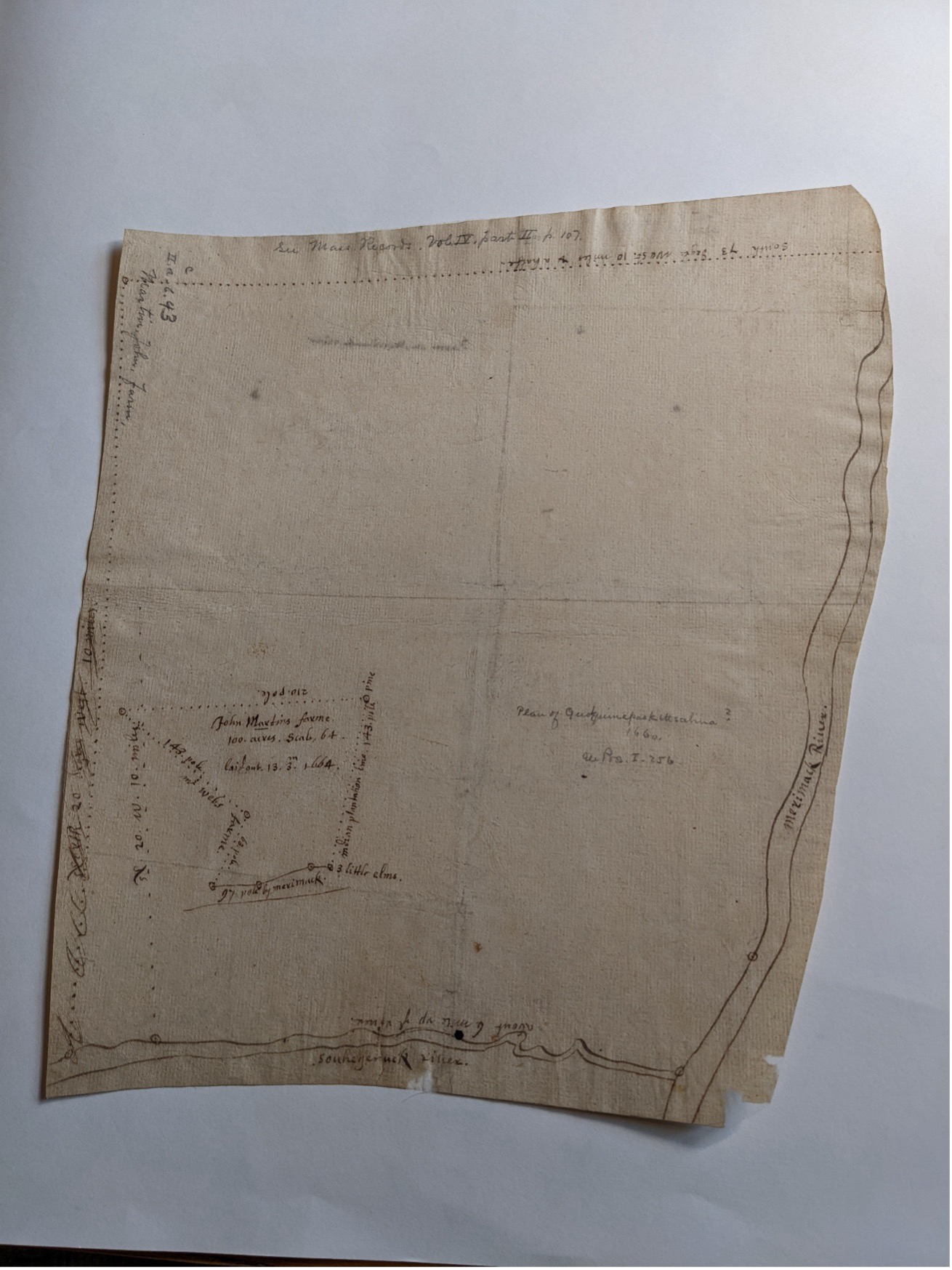
For colonial farmers in the 1660s, survey maps novelly visualized an entire plot of land. A glance replaced the need to read a multi-page description. Perhaps the aesthetic or technical qualities of these maps left lasting impressions on farmers. They likely would have first encountered them during clashes over borders in which a town or colony summoned surveyors to create maps to be powerful courtroom evidence. Many farmers may have seen their property threatened by such maps. In the 1640s and beyond, even the colonial governments of Massachusetts Bay (who made maps) and Connecticut (who initially did not) debated whether documents served as strong legal evidence in their border contests.

Figure 3: Jonathan Danforth, [Manuscript Map of a Plan of John Martin’s Farm], 1660, Massachusetts Historical Society, Mss. Large 1660. Collection of the Massachusetts Historical Society.

In this context, colonists scratched lines on pages and lodged them as legal evidence in property disagreements. This was nowhere more the case than in the dispute between New London and Lyme over their boundaries in the 1670s. Lyme sat on the east side of the Connecticut River, while its neighbor New London had been established further east along the Thames/Pequot River. Their borders overlapped by several miles, including a valuable piece of coastal meadowland called Black Point.

In August 1671, the disagreement led to a brawl between dozens of colonists from both towns who marched to the disputed land to supposedly mow the grass. Colonists started by hurling insults at each other. The Lymers, led by the litigious Mark Griswold, brought a constable and an official proclamation of their claim. After being presented with the document, one New Londoner, John Beber, declared “We care not a fart for your paper you may keep it to wipe your breach.” He and other New Londoners began to aggressively mow with their scythes, until a colonist from Lyme shouted, “I charge you to keep the King’s Peace” and threw a punch. Both groups of colonists revealed their cudgels and sticks and began to brawl. The fighting only concluded when a New London colonist “knockt one man [Richard Smith] for dead” by stabbing him with a pitchfork.

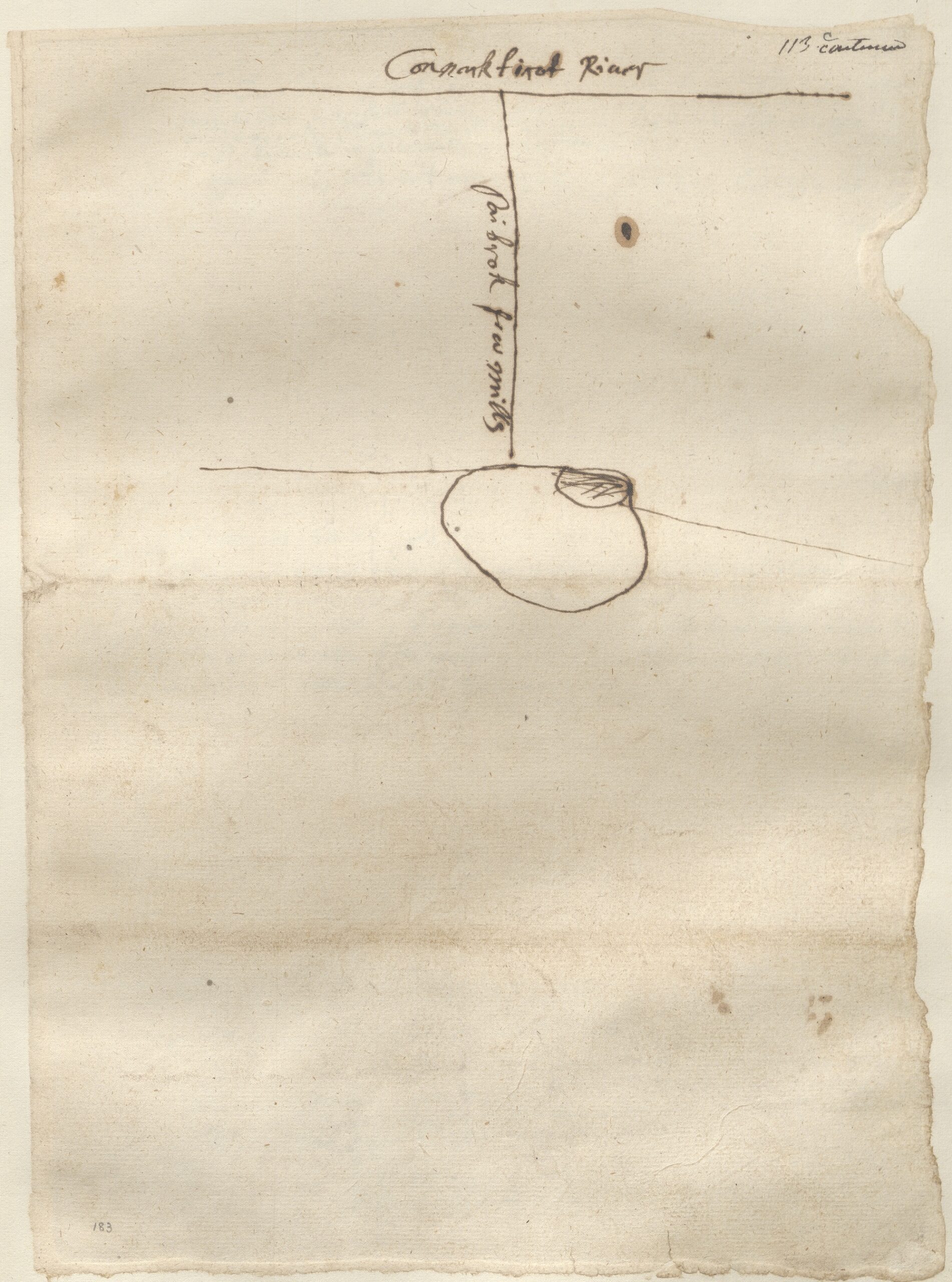
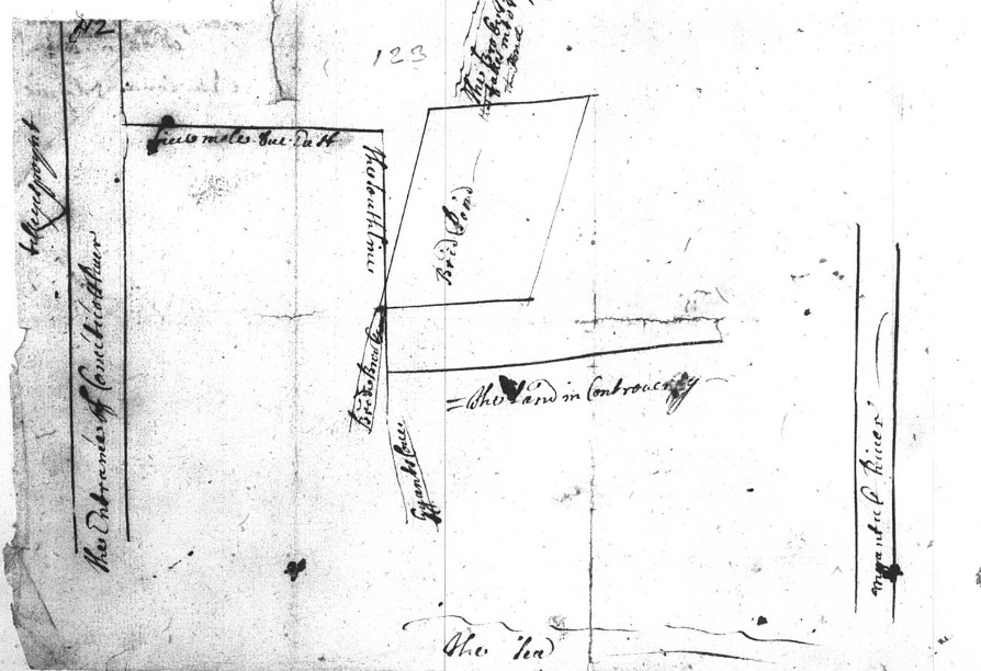
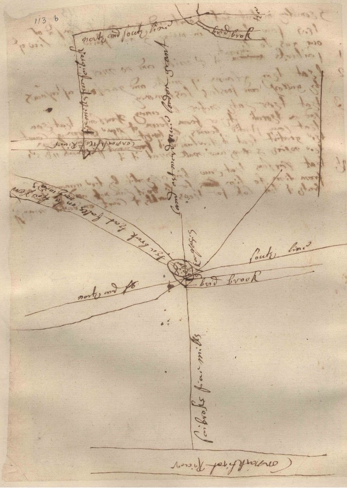
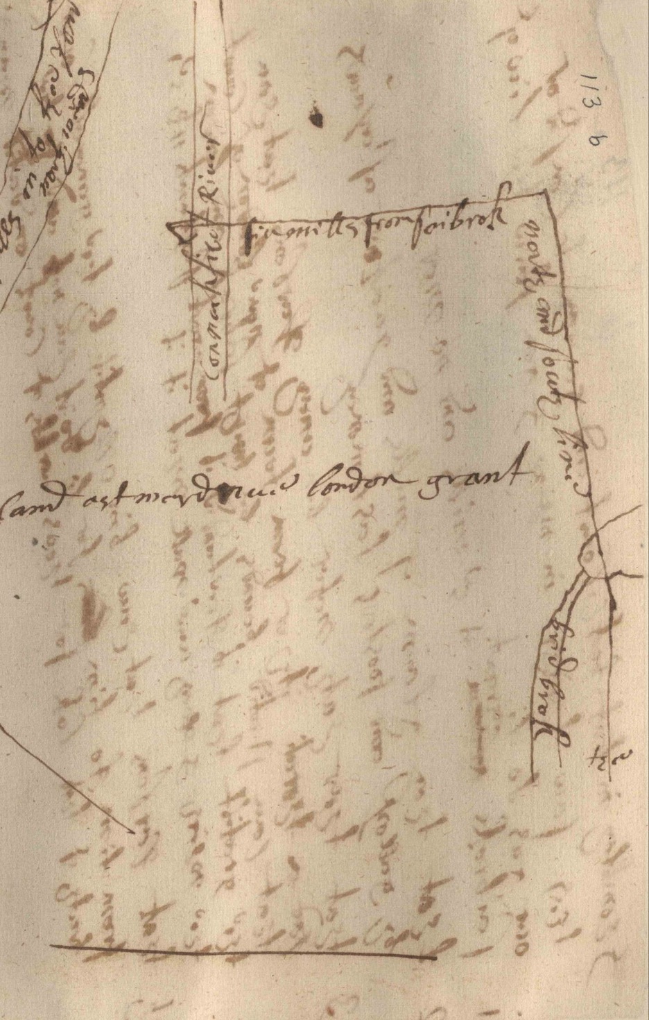
So many people from coastal Connecticut were involved in the conflict that the controversy was addressed by the county court in distant Harford. There, officials collected testimony from participants. Each man claimed that his faction had been peaceful and that the other had initiated the fight. More than a dozen witnesses described the violent controversy. Unexpectedly, four maps were nestled among their evocative accounts. These maps (Figures 4-7) were all made by untrained colonial farmers or the court’s secretary and one even contains two maps. The maps described the disputed land in simple and imprecise ways. Each shows the Connecticut River with a single line on the left, “Brid Pond” towards the center, and the “South Line” cutting from the top to bottom of the page. Yet, other landmarks (with one or two exceptions on each map), contours, and measurements are missing; all the aspects that made a cadastral map a powerful piece of legal evidence are absent.

Figure 4: [Map of New London and Lyme], Circa 1671. Connecticut State Library, Towns & Lands, Series 1, Vol. 1 before 1695, #113c.
Figure 5: [Map of New London and Lyme],Circa 1671. Connecticut State Library, Towns & Lands, Series 1, Vol. 1 before 1695, #112.
Figure 6: Mark Griswold[?], [Map of New London and Lyme],Circa 1671. Connecticut State Library, Towns & Lands, Series 1, Vol. 1 before 1695, #113b.
Figure 7: Zoomed selection of Figure 4

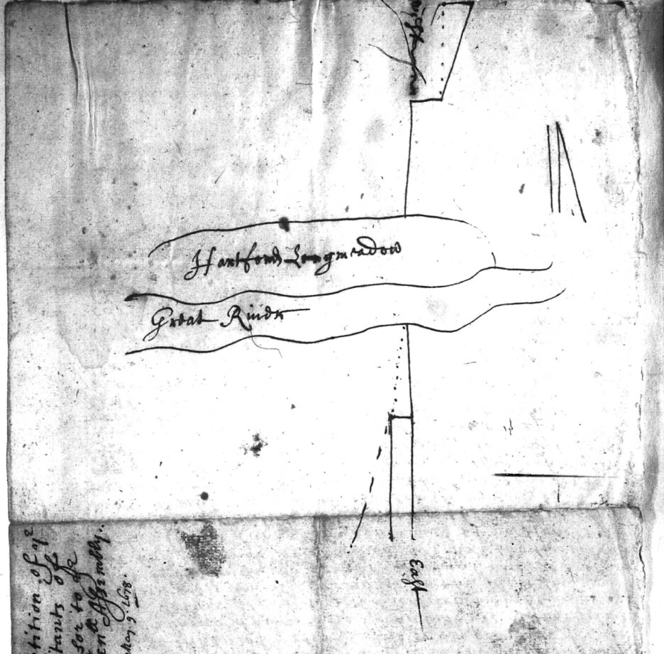
The inhabitants of New London and Lyme were not the only Connecticuters who sketched maps in the 1670s. The townspeople of Windsor made a slightly more formal one in May 1678 and included it within a petition to the Connecticut General Assembly. Shortly before they presented the petition, colonists from Massachusetts Bay began to establish a new town to the north and quickly infringed upon the Windsor townspeople’s usufruct rights to grazing and timber lands, at least according to the Connecticuters. In response, the Windsor faction sought the aid of the Connecticut government and made every argument they could in favor of their claims. They even noted that it was “God who laies out the lines of the Habitation of men.” To relieve their plight, they called for a new “running” of the border between the two colonies at the “common charge.” Interestingly, the map is not referenced in the text of the petition, leaving its argumentative purpose unclear. The usage of “prict” (dotted) lines and angles presents a distorted mirror to more professional surveys, but with none of the spatial precision.

Figure 8: Petition of the inhabitants of Windsor to the General Assembly of Connecticut, May 9, 1678. Connecticut State Library, Colonial Boundaries, Ser. 1, v. 3-7, 7b.

Colonists would have had to be delusional to believe that these lines would match the legal evidence provided by trained surveyors. So why make them? Two things are worth considering. First, these maps generally appeared in land records that included very few maps made by professional surveyors. Second, these maps (excepting the Windsor map) do not appear to have been made prior to court proceedings. The townspeople of New London and Lyme drew their maps for court clerks during legal proceedings, their disorganization hinting at haste.

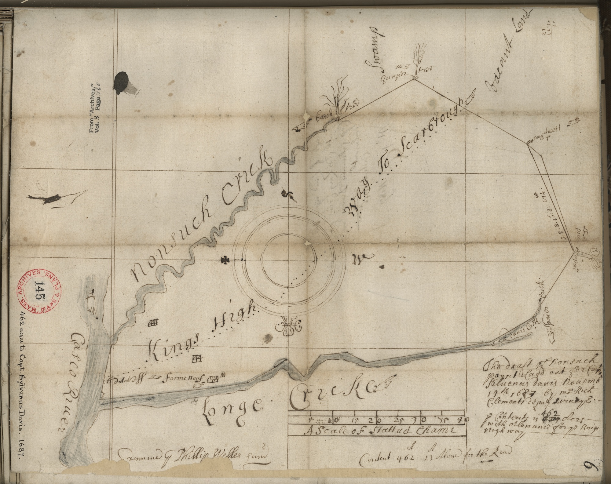
Figure 9: Richard Clements, “The Draft of Nonsuch Poynt,” 1687. Third Series Maps. 33:6, Plan of tract of Nonsuch Point in Falmouth, ME, surveyed for Capt. Sylvanus Davis, 14 March 1687. SC1/series 50x Massachusetts Archives. Boston, Massachusetts. Courtesy of the Massachusetts Archives.

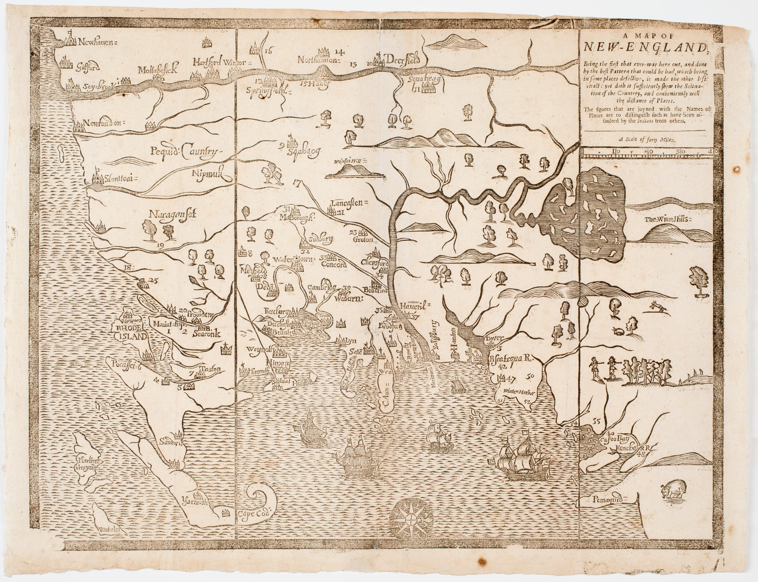
These maps represent a changing culture. While the agrarian lives of English settlers did not necessitate a top-down view in their daily lives, maps may have appealed to a new sense of place. Could they have been pursuing the same impulse as the wealthy estate owners in England, visualizing the land from above and demonstrating their new ideas in the courtroom? In broader English cartographic culture, the ability to show land from this perspective was tied to declarations of ownership and mastery. While assertions of accuracy bolstered the legitimacy of the claim implicitly contained within a map, they were not essential. Take, for example, the John Foster map of New England made during King Philip’s War. The visual style of the map does not make the same claims to accuracy as other maps from the period yet still asserts English domination during wartime through the depiction of dense settlements.

Figure 10: A Map of New-England (Boston: John Foster, 1677). Courtesy, American Antiquarian Society.

As mentioned above, New England townspeople drew these sketch maps as English spatial culture was changing. In addition to the advent of surveyors, colonists were shifting how they kept records about the landscape. While colonists regularly discussed Indigenous communities in their land records during their first twenty years in New England, often relying on their guidance and using their placenames, this was no longer the case by the 1640s. Colonists, at least on paper, replaced Algonquian experts with English surveyors. These surveyors wrote surveys and made maps using new placenames, coinciding with acts by colonial governments to rename towns with more English sounding names throughout the 1640s and 1650s. For example, in English records Tunxis became Farmington, Seacunck became Rehoboth, and Naswett became Eastham. I also found that the rise in intra-English land disputes furthered this archival shift; a proliferation of records using English terms and centering on English ownership of the land presented the illusion of a region devoid of Algonquian inhabitants.

These maps, and the land disputes they are inseparable from, need to be understood in that context. They visualized a colonial fantasy of “New England” that excluded the presence and often, the legacy of Algonquian-speaking communities. The New London/Lyme dispute took place on territory that the English had seized by “right of conquest” thirty-four years prior. Consequently, when one of the 1671 brawlers declared “The Land is ours and hear we will stand and spend our Blouds Befour we will lose itt,” he was echoing a legacy of violence towards Indigenous peoples. Pequot and Niantic wigwams still dotted the territory, albeit as “tenants” of English landlords or by “grants” declared by English towns. Tellingly, the testimony of all English involved ignored that the Niantic sachem Joshua had also made claims to Black Point and other parts of the contested land. According to documents from the following year, 1672, the Niantics had been “improving” the land. The Connecticut General Court, unlike the men from New London and Lyme, acknowledged the claim. However, they also attempted to undermine Joshua’s assertions of sovereignty in their declarations, requiring him to pay the English of Lyme “a wolfe’s head every year.” In Algonquian political culture, subjects of a sachem paid them wolf pelts as an acknowledgement of their authority. Here, the English asserted that they held that sovereignty.

With this struggle for legitimacy and colonial claims of sovereignty in mind, it seems to be no coincidence that the townspeople of Lyme and New London, living in conquered Pequot land, made more sketch maps than appear in any other local land record in New England. This mirrored the activities of trained surveyors elsewhere. On the border of Massachusetts and New Hampshire, surveyors from the Bay made dozens of maps of disputed territory that ignored the existence of any New Hampshire claim. And in 1671 in Conecticut, through English dispute and vernacular mapping, Indigenous claims were further rendered invisible. 

Ultimately, these maps were made by invaders and colonists. They walked on pathways not of their own making, filled in unfamiliar swamps, and cut back forests that bewildered them. Even on the colonial periphery of a budding English cartographic culture, settlers used maps as tools to claim ownership and power. While the maps may not have won court battles, they helped the colonists present a version of the Northeast that was theirs. Thus, in the context of the settlers’ seizure of land, these “bad” maps were not useless, but rather effectively served settlers in naturalizing their conquest of Native land.

Further Reading:

Bruckner, Martin ed. Early American Cartographies. Chapel Hill: The University of North Carolina Press, 2011.  

Bruckner, Martin. The Geographic Revolution in Early America: Maps, Literacy, and National Identity. Chapel Hill: The University of North Carolina Press, 2006.  

Greer, Allan. Property and Dispossession: Natives, Empires and Land in Early Modern North America. Cambridge: Cambridge University Press, 2018. 

Pearce, Margaret. “Encroachment by Word, Axis, and Tree: Mapping Techniques from the Colonization of New England.” Cartographic Perspectives 48 (2004): 24–38. 


This article originally appeared in October 2026.


Nathan Braccio is an Assistant Professor of History at Clark University. His research and teaching focuses on colonial America, Indigenous America, and environmental history. His research has been published in a variety of journals, including Ethnohistory and Early American Studies.

image_pdfSave to PDFimage_printPrint